Goascorán geodata
Goascorán (Valle) is a populated place; located in Honduras in America/Tegucigalpa (GMT-6) time zone. With population of 1,350 people, there are 274 cities with bigger population in this country. Compared to other cities in Honduras, 93.6% of cities are located further ↑North; 50.4% of cities are located further ←West and 77.8% of cities have higher elevation than Goascorán. Note1


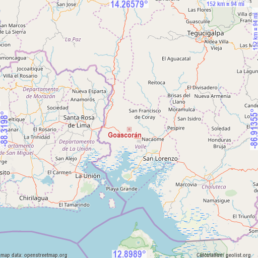
Goascorán GPS coordinates[2]
13° 34' 59.988" North, 87° 37' 0.012" West
| Map corner | latitude | longitude |
|---|---|---|
| Upper-left | 14.26579°, | -88.3198° |
| Center: | 13.58333°, | -87.61667° |
| Lower-right: | 12.8989°, | -86.91355° |
| Map W x H: | 152×152 km | = 94.4×94.4mi |
| max Lat: | 16.45° ⇑93.6% North |
| Goascorán: | 13.58333° |
| min Lat: | ⇓6.4% South 13.11667° |
| min Long | Goascorán | max Long |
| -89.23333° | -87.61667° | -83.23333° |
| W 50.4%⇐ | ⇒49.6% E |
Elevation
Elevation of Goascorán is 103 m = 338 ft, and this is 458.2 m = 1503 ft below average elevation for this country.
| Max E: |
1811 m = 5942 ft | 77.8% |
| Avg. | 561.2 m = 1841 ft | |
| Goascorán | 103 m = 338 ft | |
Min E: |
1 m = 3 ft | 22.2% |
See also: Honduras elevation on elevation.city.
Geographical zone
Goascorán is located in North Torrid zone (between Equator and Tropic of Cancer). Distance of this Northern Tropic circle is 1095.6 km =680.8 mi to North.| Distance of | km | miles | from Goascorán |
|---|---|---|---|
| North Pole | 8496.7 | 5279.6 | to North |
| Arctic Circle | 5890.8 | 3660.4 | to North |
| Tropic Cancer | 1095.6 | 680.8 | to North |
| Equator | 1510.3 | 938.5 | to South |


Nearby cities:
15 places around Goascorán: (largest is in red/bold)
• Agua Fría
14.6 km =9.1 mi,  150°
150°
• Alubarén
28.5 km =17.7 mi,  34°
34°
• Aramecina
20.4 km =12.7 mi,  330°
330°
• El Cubolero
14.1 km =8.8 mi,  202°
202°
• El Guapinol
26 km =16.2 mi,  38°
38°
• El Guayabo
21.4 km =13.3 mi,  119°
119°
• El Tular
17 km =10.6 mi,  139°
139°
• Jícaro Galán
20.1 km =12.5 mi,  106°
106°
• La Alianza
14.1 km =8.8 mi,  235°
235°
• La Criba
26.3 km =16.3 mi, 123°
• Langue
5.7 km =3.5 mi,  317°
317°
• Nacaome
14.9 km =9.3 mi, 110°
• Pespire
27.6 km =17.1 mi,  87°
87°
• San Francisco de Coray
12.6 km =7.8 mi,  46°
46°
• San Lorenzo
25.5 km =15.8 mi,  134°
134°
Sources, notices
• [Note1] Compared only with cities in Honduras existing in our database
• [Src1] Map data: © OpenStreetMap contributors (CC-BY-SA)
• [Src2] Other city data from geonames.org with taken over terms of usage.
• [Src3] Geographical zone / Annual Mean Temperature by Robert A. Rohde @ Wikipedia
