Aramecina geodata
Aramecina (Valle) is a populated place; located in Honduras in America/Tegucigalpa (GMT-6) time zone. With population of 1,071 people, there are 376 cities with bigger population in this country. Compared to other cities in Honduras, 92% of cities are located further ↑North; 53.6% of cities are located further →East and 76% of cities have higher elevation than Aramecina. Note1


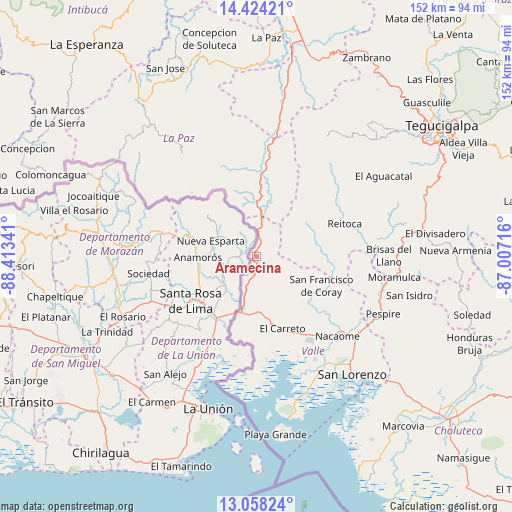
Aramecina GPS coordinates[2]
13° 44' 31.992" North, 87° 42' 37.008" West
| Map corner | latitude | longitude |
|---|---|---|
| Upper-left | 14.42421°, | -88.41341° |
| Center: | 13.74222°, | -87.71028° |
| Lower-right: | 13.05824°, | -87.00716° |
| Map W x H: | 151.9×151.9 km | = 94.4×94.4mi |
| max Lat: | 16.45° ⇑92% North |
| Aramecina: | 13.74222° |
| min Lat: | ⇓8% South 13.11667° |
| min Long | Aramecina | max Long |
| -89.23333° | -87.71028° | -83.23333° |
| W 46.4%⇐ | ⇒53.6% E |
Elevation
Elevation of Aramecina is 136 m = 446 ft, and this is 425.2 m = 1395 ft below average elevation for this country.
| Max E: |
1811 m = 5942 ft | 76% |
| Avg. | 561.2 m = 1841 ft | |
| Aramecina | 136 m = 446 ft | |
Min E: |
1 m = 3 ft | 24% |
See also: Honduras elevation on elevation.city.
Geographical zone
Aramecina is located in North Torrid zone (between Equator and Tropic of Cancer). Distance of this Northern Tropic circle is 1077.9 km =669.8 mi to North.| Distance of | km | miles | from Aramecina |
|---|---|---|---|
| North Pole | 8479.1 | 5268.7 | to North |
| Arctic Circle | 5873.2 | 3649.4 | to North |
| Tropic Cancer | 1077.9 | 669.8 | to North |
| Equator | 1528 | 949.5 | to South |


Nearby cities:
15 places around Aramecina: (largest is in red/bold)
• Agua Fría
34.9 km =21.7 mi,  150°
150°
• Alubarén
26.7 km =16.6 mi,  77°
77°
• El Cubolero
31 km =19.3 mi,  171°
171°
• El Guapinol
26.5 km =16.5 mi, 84°
• El Guayabo
40.2 km =25 mi,  134°
134°
• El Porvenir
39.4 km =24.5 mi,  86°
86°
• El Tular
37.2 km =23.1 mi, 145°
• Goascorán
20.4 km =12.7 mi, 150°
• Jícaro Galán
37.5 km =23.3 mi, 128°
• La Alianza
25.6 km =15.9 mi,  183°
183°
• Langue
14.9 km =9.3 mi,  155°
155°
• Nacaome
33.2 km =20.6 mi, 133°
• Reitoca
28 km =17.4 mi,  70°
70°
• San Antonio del Norte
15.8 km =9.8 mi,  2°
2°
• San Francisco de Coray
21.2 km =13.2 mi,  115°
115°
Sources, notices
• [Note1] Compared only with cities in Honduras existing in our database
• [Src1] Map data: © OpenStreetMap contributors (CC-BY-SA)
• [Src2] Other city data from geonames.org with taken over terms of usage.
• [Src3] Geographical zone / Annual Mean Temperature by Robert A. Rohde @ Wikipedia
