Alubarén geodata
Alubarén (Francisco Morazán) is a populated place; located in Honduras in America/Tegucigalpa (GMT-6) time zone. With population of 983 people, there are 426 cities with bigger population in this country. Compared to other cities in Honduras, 91.4% of cities are located further ↑North; 54.8% of cities are located further ←West and 65% of cities have higher elevation than Alubarén. Note1


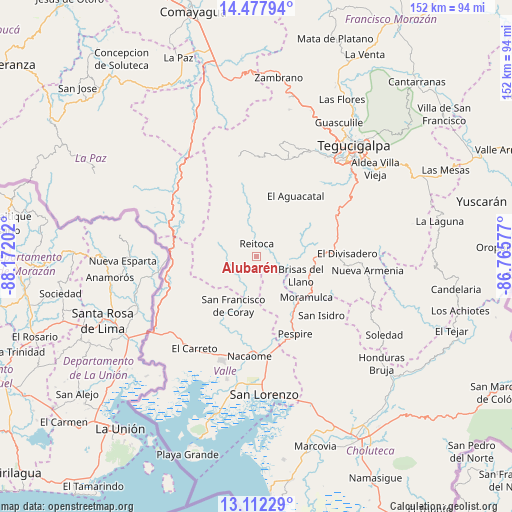
Alubarén GPS coordinates[2]
13° 47' 45.996" North, 87° 28' 8.004" West
| Map corner | latitude | longitude |
|---|---|---|
| Upper-left | 14.47794°, | -88.17202° |
| Center: | 13.79611°, | -87.46889° |
| Lower-right: | 13.11229°, | -86.76577° |
| Map W x H: | 151.8×151.8 km | = 94.3×94.3mi |
| max Lat: | 16.45° ⇑91.4% North |
| Alubarén: | 13.79611° |
| min Lat: | ⇓8.6% South 13.11667° |
| min Long | Alubarén | max Long |
| -89.23333° | -87.46889° | -83.23333° |
| W 54.8%⇐ | ⇒45.2% E |
Elevation
Elevation of Alubarén is 311 m = 1020 ft, and this is 250.2 m = 821 ft below average elevation for this country.
| Max E: |
1811 m = 5942 ft | 65% |
| Avg. | 561.2 m = 1841 ft | |
| Alubarén | 311 m = 1020 ft | |
Min E: |
1 m = 3 ft | 35% |
See also: Honduras elevation on elevation.city.
Geographical zone
Alubarén is located in North Torrid zone (between Equator and Tropic of Cancer). Distance of this Northern Tropic circle is 1071.9 km =666 mi to North.| Distance of | km | miles | from Alubarén |
|---|---|---|---|
| North Pole | 8473.1 | 5264.9 | to North |
| Arctic Circle | 5867.2 | 3645.7 | to North |
| Tropic Cancer | 1071.9 | 666 | to North |
| Equator | 1534 | 953.2 | to South |


Nearby cities:
15 places around Alubarén: (largest is in red/bold)
• Aramecina
26.7 km =16.6 mi,  257°
257°
• Cerro Grande
23.7 km =14.7 mi,  84°
84°
• El Guapinol
3.3 km =2.1 mi,  175°
175°
• El Porvenir
13.8 km =8.6 mi,  106°
106°
• Goascorán
28.5 km =17.7 mi,  214°
214°
• Jícaro Galán
29.6 km =18.4 mi,  173°
173°
• Langue
27.8 km =17.3 mi,  225°
225°
• Nacaome
29 km =18 mi, 183°
• Ojojona
24.2 km =15 mi,  50°
50°
• Pespire
25.5 km =15.8 mi,  152°
152°
• Reitoca
3.3 km =2.1 mi,  6°
6°
• Sabanagrande
22.7 km =14.1 mi,  86°
86°
• San Antonio del Norte
27.1 km =16.8 mi,  291°
291°
• San Francisco de Coray
16.5 km =10.3 mi,  204°
204°
• Santa Ana
26.1 km =16.2 mi, 54°
Sources, notices
• [Note1] Compared only with cities in Honduras existing in our database
• [Src1] Map data: © OpenStreetMap contributors (CC-BY-SA)
• [Src2] Other city data from geonames.org with taken over terms of usage.
• [Src3] Geographical zone / Annual Mean Temperature by Robert A. Rohde @ Wikipedia
