Langue geodata
Langue (Valle) is a populated place; located in Honduras in America/Tegucigalpa (GMT-6) time zone. With population of 3,679 people, there are 87 cities with bigger population in this country. Compared to other cities in Honduras, 93.2% of cities are located further ↑North; 51.2% of cities are located further →East and 75% of cities have higher elevation than Langue. Note1


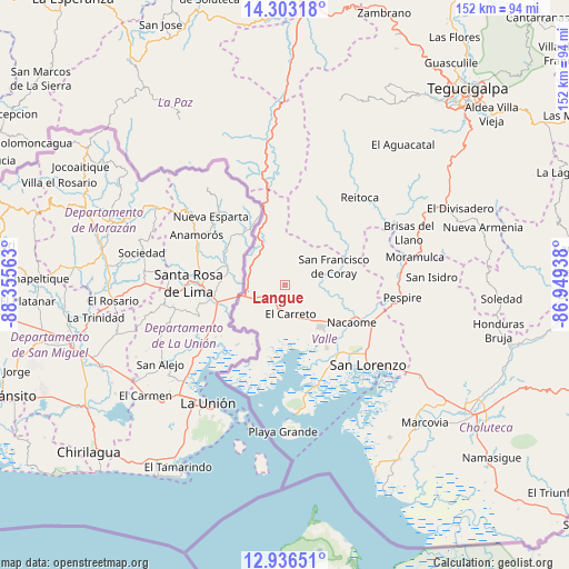
Langue GPS coordinates[2]
13° 37' 14.988" North, 87° 39' 9" West
| Map corner | latitude | longitude |
|---|---|---|
| Upper-left | 14.30318°, | -88.35563° |
| Center: | 13.62083°, | -87.6525° |
| Lower-right: | 12.93651°, | -86.94938° |
| Map W x H: | 152×152 km | = 94.4×94.4mi |
| max Lat: | 16.45° ⇑93.2% North |
| Langue: | 13.62083° |
| min Lat: | ⇓6.8% South 13.11667° |
| min Long | Langue | max Long |
| -89.23333° | -87.6525° | -83.23333° |
| W 48.8%⇐ | ⇒51.2% E |
Elevation
Elevation of Langue is 151 m = 495 ft, and this is 410.2 m = 1346 ft below average elevation for this country.
| Max E: |
1811 m = 5942 ft | 75% |
| Avg. | 561.2 m = 1841 ft | |
| Langue | 151 m = 495 ft | |
Min E: |
1 m = 3 ft | 25% |
See also: Honduras elevation on elevation.city.
Geographical zone
Langue is located in North Torrid zone (between Equator and Tropic of Cancer). Distance of this Northern Tropic circle is 1091.4 km =678.2 mi to North.| Distance of | km | miles | from Langue |
|---|---|---|---|
| North Pole | 8492.6 | 5277.1 | to North |
| Arctic Circle | 5886.7 | 3657.8 | to North |
| Tropic Cancer | 1091.4 | 678.2 | to North |
| Equator | 1514.5 | 941.1 | to South |


Nearby cities:
15 places around Langue: (largest is in red/bold)
• Agua Fría
20.1 km =12.5 mi,  147°
147°
• Alubarén
27.8 km =17.3 mi,  45°
45°
• Aramecina
14.9 km =9.3 mi,  335°
335°
• El Cubolero
17.2 km =10.7 mi,  185°
185°
• El Guapinol
25.8 km =16 mi, 51°
• El Guayabo
26.9 km =16.7 mi,  122°
122°
• El Tular
22.7 km =14.1 mi,  139°
139°
• Goascorán
5.7 km =3.5 mi, 137°
• Jícaro Galán
25.1 km =15.6 mi,  113°
113°
• La Alianza
14.4 km =8.9 mi,  212°
212°
• Nacaome
20.2 km =12.6 mi, 117°
• Reitoca
30.5 km =19 mi,  41°
41°
• San Antonio del Norte
29.8 km =18.5 mi,  349°
349°
• San Francisco de Coray
13.7 km =8.5 mi,  70°
70°
• San Lorenzo
31.2 km =19.4 mi,  134°
134°
Sources, notices
• [Note1] Compared only with cities in Honduras existing in our database
• [Src1] Map data: © OpenStreetMap contributors (CC-BY-SA)
• [Src2] Other city data from geonames.org with taken over terms of usage.
• [Src3] Geographical zone / Annual Mean Temperature by Robert A. Rohde @ Wikipedia
