El Zapote geodata
El Zapote (Cortés) is a populated place; located in Honduras in America/Tegucigalpa (GMT-6) time zone. With population of 970 people, there are 436 cities with bigger population in this country. Compared to other cities in Honduras, 57.8% of cities are located further ↓South; 57.6% of cities are located further →East and 59.8% of cities have higher elevation than El Zapote. Note1


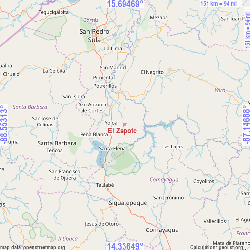
El Zapote GPS coordinates[2]
15° 1' 0.012" North, 87° 51' 0" West
| Map corner | latitude | longitude |
|---|---|---|
| Upper-left | 15.69469°, | -88.55313° |
| Center: | 15.01667°, | -87.85° |
| Lower-right: | 14.33649°, | -87.14688° |
| Map W x H: | 151×151 km | = 93.8×93.8mi |
| max Lat: | 16.45° ⇑42.2% North |
| El Zapote: | 15.01667° |
| min Lat: | ⇓57.8% South 13.11667° |
| min Long | El Zapote | max Long |
| -89.23333° | -87.85° | -83.23333° |
| W 42.4%⇐ | ⇒57.6% E |
Elevation
Elevation of El Zapote is 410 m = 1345 ft, and this is 151.2 m = 496 ft below average elevation for this country.
| Max E: |
1811 m = 5942 ft | 59.8% |
| Avg. | 561.2 m = 1841 ft | |
| El Zapote | 410 m = 1345 ft | |
Min E: |
1 m = 3 ft | 40.2% |
See also: Honduras elevation on elevation.city.
Geographical zone
El Zapote is located in North Torrid zone (between Equator and Tropic of Cancer). Distance of this Northern Tropic circle is 936.2 km =581.7 mi to North.| Distance of | km | miles | from El Zapote |
|---|---|---|---|
| North Pole | 8337.4 | 5180.6 | to North |
| Arctic Circle | 5731.5 | 3561.4 | to North |
| Tropic Cancer | 936.2 | 581.7 | to North |
| Equator | 1669.7 | 1037.5 | to South |


Nearby cities:
15 places around El Zapote: (largest is in red/bold)
• Agua Azul
16.8 km =10.4 mi,  228°
228°
• Agua Azul Rancho
16.8 km =10.4 mi,  219°
219°
• Bejuco
15.8 km =9.8 mi,  325°
325°
• Cañaveral
18.3 km =11.4 mi,  258°
258°
• El Buen Pastor
18.2 km =11.3 mi,  156°
156°
• El Llano
15.3 km =9.5 mi,  346°
346°
• El Olivar
8.2 km =5.1 mi, 334°
• El Tigre
17.1 km =10.6 mi,  237°
237°
• La Guama
17.3 km =10.7 mi,  211°
211°
• Los Caminos
14.6 km =9.1 mi, 239°
• Oropéndolas
8.9 km =5.5 mi,  270°
270°
• Río Lindo
14.4 km =8.9 mi,  277°
277°
• San Buenaventura
16.1 km =10 mi, 270°
• San Francisco de Yojoa
12.5 km =7.8 mi, 270°
• Santa Cruz de Yojoa
6.5 km =4 mi, 235°
Sources, notices
• [Note1] Compared only with cities in Honduras existing in our database
• [Src1] Map data: © OpenStreetMap contributors (CC-BY-SA)
• [Src2] Other city data from geonames.org with taken over terms of usage.
• [Src3] Geographical zone / Annual Mean Temperature by Robert A. Rohde @ Wikipedia
