El Achiotal geodata
El Achiotal (Lempira) is a populated place; located in Honduras in America/Tegucigalpa (GMT-6) time zone. With population of 1,210 people, there are 319 cities with bigger population in this country. Compared to other cities in Honduras, 83.6% of cities are located further ↑North; 89.8% of cities are located further →East and 51.8% of cities have higher elevation than El Achiotal. Note1


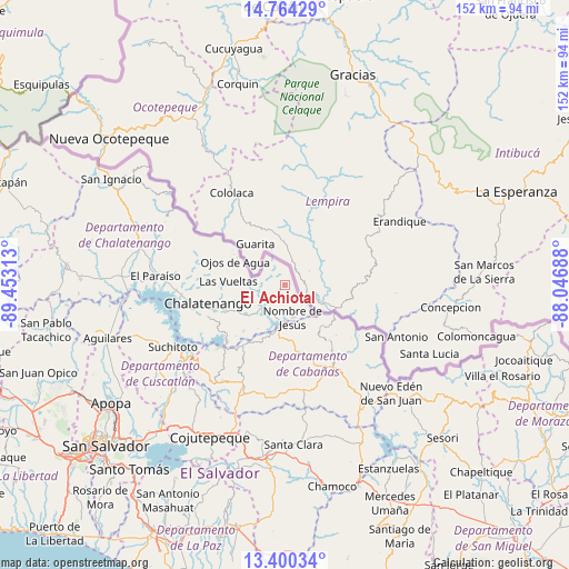
El Achiotal GPS coordinates[2]
14° 4' 59.988" North, 88° 45' 0" West
| Map corner | latitude | longitude |
|---|---|---|
| Upper-left | 14.76429°, | -89.45313° |
| Center: | 14.08333°, | -88.75° |
| Lower-right: | 13.40034°, | -88.04688° |
| Map W x H: | 151.7×151.7 km | = 94.3×94.3mi |
| max Lat: | 16.45° ⇑83.6% North |
| El Achiotal: | 14.08333° |
| min Lat: | ⇓16.4% South 13.11667° |
| min Long | El Achiotal | max Long |
| -89.23333° | -88.75° | -83.23333° |
| W 10.2%⇐ | ⇒89.8% E |
Elevation
Elevation of El Achiotal is 537 m = 1762 ft, and this is 24.2 m = 79 ft below average elevation for this country.
| Max E: |
1811 m = 5942 ft | 51.8% |
| Avg. | 561.2 m = 1841 ft | |
| El Achiotal | 537 m = 1762 ft | |
Min E: |
1 m = 3 ft | 48.2% |
See also: Honduras elevation on elevation.city.
Geographical zone
El Achiotal is located in North Torrid zone (between Equator and Tropic of Cancer). Distance of this Northern Tropic circle is 1040 km =646.2 mi to North.| Distance of | km | miles | from El Achiotal |
|---|---|---|---|
| North Pole | 8441.1 | 5245.1 | to North |
| Arctic Circle | 5835.3 | 3625.9 | to North |
| Tropic Cancer | 1040 | 646.2 | to North |
| Equator | 1565.9 | 973 | to South |


Nearby cities:
15 places around El Achiotal: (largest is in red/bold)
• Azacualpa
44.5 km =27.7 mi,  62°
62°
• Belén Gualcho
44.8 km =27.8 mi,  353°
353°
• Camasca
40.6 km =25.2 mi,  103°
103°
• Cololaca
28.1 km =17.5 mi,  329°
329°
• El Granzal
37.4 km =23.2 mi,  340°
340°
• El Tránsito
37.9 km =23.5 mi, 331°
• Erandique
34.8 km =21.6 mi, 61°
• Guatemalita
14.8 km =9.2 mi,  75°
75°
• Jiquinlaca
44.1 km =27.4 mi, 102°
• La Virtud
6.5 km =4 mi,  124°
124°
• San Francisco del Valle
44.5 km =27.7 mi, 331°
• San Marcos
41.3 km =25.7 mi, 328°
• Santa Teresa
42.9 km =26.7 mi,  321°
321°
• Sensenti
48.7 km =30.3 mi, 336°
• Yaruchel
50.5 km =31.4 mi, 351°
Sources, notices
• [Note1] Compared only with cities in Honduras existing in our database
• [Src1] Map data: © OpenStreetMap contributors (CC-BY-SA)
• [Src2] Other city data from geonames.org with taken over terms of usage.
• [Src3] Geographical zone / Annual Mean Temperature by Robert A. Rohde @ Wikipedia
