Dulce Nombre de Culmí geodata
Dulce Nombre de Culmí (Olancho) is a populated place; located in Honduras in America/Tegucigalpa (GMT-6) time zone. With population of 2,091 people, there are 174 cities with bigger population in this country. Compared to other cities in Honduras, 64% of cities are located further ↓South; 97.4% of cities are located further ←West and 52.8% of cities have higher elevation than Dulce Nombre de Culmí. Note1


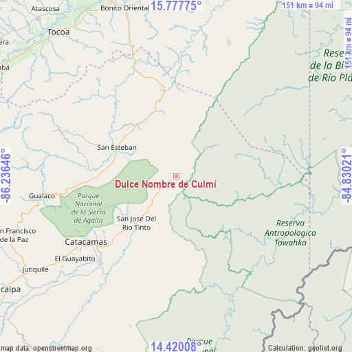
Dulce Nombre de Culmí GPS coordinates[2]
15° 6' 0" North, 85° 31' 59.988" West
| Map corner | latitude | longitude |
|---|---|---|
| Upper-left | 15.77775°, | -86.23646° |
| Center: | 15.1°, | -85.53333° |
| Lower-right: | 14.42008°, | -84.83021° |
| Map W x H: | 151×151 km | = 93.8×93.8mi |
| max Lat: | 16.45° ⇑36% North |
| Dulce Nombre de Culmí: | 15.1° |
| min Lat: | ⇓64% South 13.11667° |
| min Long | Dulce Nombre de | max Long |
| -89.23333° | -85.53333° | -83.23333° |
| W 97.4%⇐ | ⇒2.6% E |
Elevation
Elevation of Dulce Nombre de Culmí is 526 m = 1726 ft, and this is 35.2 m = 115 ft below average elevation for this country.
| Max E: |
1811 m = 5942 ft | 52.8% |
| Avg. | 561.2 m = 1841 ft | |
| Dulce Nombre de Culmí | 526 m = 1726 ft | |
Min E: |
1 m = 3 ft | 47.2% |
See also: Honduras elevation on elevation.city.
Geographical zone
Dulce Nombre de Culmí is located in North Torrid zone (between Equator and Tropic of Cancer). Distance of this Northern Tropic circle is 927 km =576 mi to North.| Distance of | km | miles | from Dulce Nombre de Culmí |
|---|---|---|---|
| North Pole | 8328.1 | 5174.8 | to North |
| Arctic Circle | 5722.2 | 3555.6 | to North |
| Tropic Cancer | 927 | 576 | to North |
| Equator | 1679 | 1043.3 | to South |


Nearby cities:
15 places around Dulce Nombre de Culmí: (largest is in red/bold)
• Arimís
61.3 km =38.1 mi,  234°
234°
• Bonito Oriental
75.2 km =46.7 mi,  343°
343°
• Corocito
77.1 km =47.9 mi, 339°
• El Guayabito
61.3 km =38.1 mi,  241°
241°
• Gualaco
58.3 km =36.2 mi,  261°
261°
• Jutiquile
72.9 km =45.3 mi, 234°
• La Esperanza
64.4 km =40 mi, 337°
• Laguna Seca
75.4 km =46.9 mi, 233°
• Punuare
61.9 km =38.5 mi, 228°
• San Esteban
28.3 km =17.6 mi,  296°
296°
• San Francisco de Becerra
80 km =49.7 mi, 229°
• San Francisco de la Paz
75 km =46.6 mi,  252°
252°
• San José de Río Tinto
25.8 km =16 mi,  224°
224°
• Santa María del Real
58.1 km =36.1 mi, 230°
• Taujica
78.4 km =48.7 mi,  328°
328°
Sources, notices
• [Note1] Compared only with cities in Honduras existing in our database
• [Src1] Map data: © OpenStreetMap contributors (CC-BY-SA)
• [Src2] Other city data from geonames.org with taken over terms of usage.
• [Src3] Geographical zone / Annual Mean Temperature by Robert A. Rohde @ Wikipedia
