San Esteban geodata
San Esteban (Olancho) is a populated place; located in Honduras in America/Tegucigalpa (GMT-6) time zone. With population of 3,439 people, there are 99 cities with bigger population in this country. Compared to other cities in Honduras, 68.8% of cities are located further ↓South; 96% of cities are located further ←West and 57.8% of cities have higher elevation than San Esteban. Note1


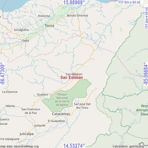
San Esteban GPS coordinates[2]
15° 12' 44.316" North, 85° 46' 11.856" West
| Map corner | latitude | longitude |
|---|---|---|
| Upper-left | 15.88969°, | -86.47309° |
| Center: | 15.21231°, | -85.76996° |
| Lower-right: | 14.53274°, | -85.06684° |
| Map W x H: | 150.9×150.9 km | = 93.8×93.8mi |
| max Lat: | 16.45° ⇑31.2% North |
| San Esteban: | 15.21231° |
| min Lat: | ⇓68.8% South 13.11667° |
| min Long | San Esteban | max Long |
| -89.23333° | -85.76996° | -83.23333° |
| W 96%⇐ | ⇒4% E |
Elevation
Elevation of San Esteban is 447 m = 1467 ft, and this is 114.2 m = 375 ft below average elevation for this country.
| Max E: |
1811 m = 5942 ft | 57.8% |
| Avg. | 561.2 m = 1841 ft | |
| San Esteban | 447 m = 1467 ft | |
Min E: |
1 m = 3 ft | 42.2% |
See also: Honduras elevation on elevation.city.
Geographical zone
San Esteban is located in North Torrid zone (between Equator and Tropic of Cancer). Distance of this Northern Tropic circle is 914.5 km =568.2 mi to North.| Distance of | km | miles | from San Esteban |
|---|---|---|---|
| North Pole | 8315.6 | 5167.1 | to North |
| Arctic Circle | 5709.7 | 3547.8 | to North |
| Tropic Cancer | 914.5 | 568.2 | to North |
| Equator | 1691.5 | 1051 | to South |


Nearby cities:
15 places around San Esteban: (largest is in red/bold)
• Arimís
53.7 km =33.4 mi,  207°
207°
• Bonito Oriental
59.6 km =37 mi,  3°
3°
• Dulce Nombre de Culmí
28.3 km =17.6 mi,  116°
116°
• El Guayabito
50.8 km =31.6 mi, 213°
• Gualaco
38.4 km =23.9 mi,  237°
237°
• La Esperanza
46.8 km =29.1 mi, 0°
• Prieta
56.8 km =35.3 mi,  316°
316°
• Punuare
57.3 km =35.6 mi,  201°
201°
• Sabá
58.7 km =36.5 mi,  298°
298°
• San Francisco de la Paz
57.8 km =35.9 mi,  233°
233°
• San José de Río Tinto
31.9 km =19.8 mi,  166°
166°
• Santa María del Real
53.2 km =33.1 mi, 201°
• Taujica
56.5 km =35.1 mi,  343°
343°
• Tocoa
57.9 km =36 mi,  334°
334°
• Zamora
56.6 km =35.2 mi, 325°
Sources, notices
• [Note1] Compared only with cities in Honduras existing in our database
• [Src1] Map data: © OpenStreetMap contributors (CC-BY-SA)
• [Src2] Other city data from geonames.org with taken over terms of usage.
• [Src3] Geographical zone / Annual Mean Temperature by Robert A. Rohde @ Wikipedia
