Cusuna geodata
Cusuna (Colón) is a populated place; located in Honduras in America/Tegucigalpa (GMT-6) time zone. With population of 1,441 people, there are 255 cities with bigger population in this country. Compared to other cities in Honduras, 97.4% of cities are located further ↓South; 97.8% of cities are located further ←West and 81.2% of cities have higher elevation than Cusuna. Note1


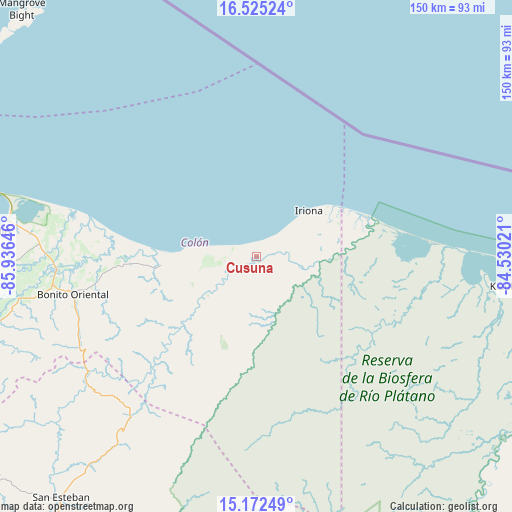
Cusuna GPS coordinates[2]
15° 51' 0" North, 85° 13' 59.988" West
| Map corner | latitude | longitude |
|---|---|---|
| Upper-left | 16.52524°, | -85.93646° |
| Center: | 15.85°, | -85.23333° |
| Lower-right: | 15.17249°, | -84.53021° |
| Map W x H: | 150.4×150.4 km | = 93.5×93.5mi |
| max Lat: | 16.45° ⇑2.6% North |
| Cusuna: | 15.85° |
| min Lat: | ⇓97.4% South 13.11667° |
| min Long | Cusuna | max Long |
| -89.23333° | -85.23333° | -83.23333° |
| W 97.8%⇐ | ⇒2.2% E |
Elevation
Elevation of Cusuna is 68 m = 223 ft, and this is 493.2 m = 1618 ft below average elevation for this country.
| Max E: |
1811 m = 5942 ft | 81.2% |
| Avg. | 561.2 m = 1841 ft | |
| Cusuna | 68 m = 223 ft | |
Min E: |
1 m = 3 ft | 18.8% |
See also: Honduras elevation on elevation.city.
Geographical zone
Cusuna is located in North Torrid zone (between Equator and Tropic of Cancer). Distance of this Northern Tropic circle is 843.6 km =524.2 mi to North.| Distance of | km | miles | from Cusuna |
|---|---|---|---|
| North Pole | 8244.7 | 5123 | to North |
| Arctic Circle | 5638.8 | 3503.8 | to North |
| Tropic Cancer | 843.6 | 524.2 | to North |
| Equator | 1762.4 | 1095.1 | to South |


Nearby cities:
15 places around Cusuna: (largest is in red/bold)
• Bonito Oriental
54.9 km =34.1 mi,  258°
258°
• Brus Laguna
81 km =50.3 mi,  97°
97°
• Corocito
59.9 km =37.2 mi, 259°
• Francia
37.4 km =23.2 mi,  270°
270°
• Jericó
79.2 km =49.2 mi,  278°
278°
• La Brea
78.6 km =48.8 mi, 265°
• La Curva
57.3 km =35.6 mi, 264°
• La Esperanza
62 km =38.5 mi,  247°
247°
• Puerto Castilla
80.6 km =50.1 mi, 283°
• Punta Piedra
7.7 km =4.8 mi,  316°
316°
• Quebrada de Arena
73.7 km =45.8 mi, 262°
• Salamá
79.2 km =49.2 mi, 261°
• Santa Rosa de Aguán
52.9 km =32.9 mi, 282°
• Taujica
75 km =46.6 mi, 257°
• Trujillo
77.4 km =48.1 mi, 275°
Sources, notices
• [Note1] Compared only with cities in Honduras existing in our database
• [Src1] Map data: © OpenStreetMap contributors (CC-BY-SA)
• [Src2] Other city data from geonames.org with taken over terms of usage.
• [Src3] Geographical zone / Annual Mean Temperature by Robert A. Rohde @ Wikipedia
