Flores geodata
Flores (Comayagua) is a populated place; located in Honduras in America/Tegucigalpa (GMT-6) time zone. With population of 3,018 people, there are 108 cities with bigger population in this country. Compared to other cities in Honduras, 78.4% of cities are located further ↑North; 52.8% of cities are located further ←West and 55.8% of cities have lower elevation than Flores. Note1


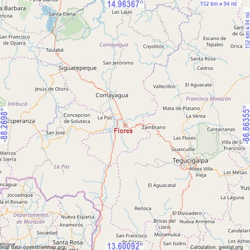
Flores GPS coordinates[2]
14° 16' 59.988" North, 87° 34' 0.012" West
| Map corner | latitude | longitude |
|---|---|---|
| Upper-left | 14.96367°, | -88.2698° |
| Center: | 14.28333°, | -87.56667° |
| Lower-right: | 13.60092°, | -86.86355° |
| Map W x H: | 151.5×151.5 km | = 94.1×94.1mi |
| max Lat: | 16.45° ⇑78.4% North |
| Flores: | 14.28333° |
| min Lat: | ⇓21.6% South 13.11667° |
| min Long | Flores | max Long |
| -89.23333° | -87.56667° | -83.23333° |
| W 52.8%⇐ | ⇒47.2% E |
Elevation
Elevation of Flores is 645 m = 2116 ft, and this is 83.8 m = 275 ft above average elevation for this country.
| Max E: |
1811 m = 5942 ft | 44.2% |
| Flores | 645 m 2116 ft | |
| Avg. | 561.2 m = 1841 ft | |
Min E: |
1 m = 3 ft | 55.8% |
See also: Honduras elevation on elevation.city.
Geographical zone
Flores is located in North Torrid zone (between Equator and Tropic of Cancer). Distance of this Northern Tropic circle is 1017.8 km =632.4 mi to North.| Distance of | km | miles | from Flores |
|---|---|---|---|
| North Pole | 8418.9 | 5231.3 | to North |
| Arctic Circle | 5813 | 3612 | to North |
| Tropic Cancer | 1017.8 | 632.4 | to North |
| Equator | 1588.2 | 986.9 | to South |


Nearby cities:
15 places around Flores: (largest is in red/bold)
• Ajuterique
18.2 km =11.3 mi,  307°
307°
• Cane
10.8 km =6.7 mi,  270°
270°
• Comayagua
20.2 km =12.6 mi,  337°
337°
• La Paz
12.8 km =8 mi,  288°
288°
• Lamaní
10.7 km =6.6 mi,  210°
210°
• Las Mercedes
0 km =0 mi,  0°
0°
• Lejamaní
17.1 km =10.6 mi,  302°
302°
• Lepaterique
26.4 km =16.4 mi,  155°
155°
• Palo Pintado
28.8 km =17.9 mi,  334°
334°
• San Sebastián
8.1 km =5 mi,  242°
242°
• Tepanguare
20.5 km =12.7 mi, 285°
• Valle de Ángeles
25.1 km =15.6 mi, 343°
• Villa de San Antonio
6.5 km =4 mi, 304°
• Yarumela
9.1 km =5.7 mi, 307°
• Zambrano
18.1 km =11.2 mi,  95°
95°
Sources, notices
• [Note1] Compared only with cities in Honduras existing in our database
• [Src1] Map data: © OpenStreetMap contributors (CC-BY-SA)
• [Src2] Other city data from geonames.org with taken over terms of usage.
• [Src3] Geographical zone / Annual Mean Temperature by Robert A. Rohde @ Wikipedia
