Victoria geodata
Victoria (Yoro) is a populated place; located in Honduras in America/Tegucigalpa (GMT-6) time zone. With population of 2,884 people, there are 118 cities with bigger population in this country. Compared to other cities in Honduras, 85.2% of cities are located further ↓South; 56.2% of cities are located further →East and 90.4% of cities have higher elevation than Victoria. Note1


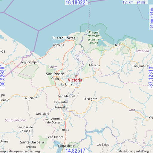
Victoria GPS coordinates[2]
15° 30' 13.716" North, 87° 49' 34.5" West
| Map corner | latitude | longitude |
|---|---|---|
| Upper-left | 16.18022°, | -88.52938° |
| Center: | 15.50381°, | -87.82625° |
| Lower-right: | 14.82517°, | -87.12313° |
| Map W x H: | 150.7×150.7 km | = 93.6×93.6mi |
| max Lat: | 16.45° ⇑14.8% North |
| Victoria: | 15.50381° |
| min Lat: | ⇓85.2% South 13.11667° |
| min Long | Victoria | max Long |
| -89.23333° | -87.82625° | -83.23333° |
| W 43.8%⇐ | ⇒56.2% E |
Elevation
Elevation of Victoria is 23 m = 75 ft, and this is 538.2 m = 1766 ft below average elevation for this country.
| Max E: |
1811 m = 5942 ft | 90.4% |
| Avg. | 561.2 m = 1841 ft | |
| Victoria | 23 m = 75 ft | |
Min E: |
1 m = 3 ft | 9.6% |
See also: Honduras elevation on elevation.city.
Geographical zone
Victoria is located in North Torrid zone (between Equator and Tropic of Cancer). Distance of this Northern Tropic circle is 882.1 km =548.1 mi to North.| Distance of | km | miles | from Victoria |
|---|---|---|---|
| North Pole | 8283.2 | 5146.9 | to North |
| Arctic Circle | 5677.3 | 3527.7 | to North |
| Tropic Cancer | 882.1 | 548.1 | to North |
| Equator | 1723.9 | 1071.2 | to South |


Nearby cities:
15 places around Victoria: (largest is in red/bold)
• Choloma
18.3 km =11.4 mi,  312°
312°
• Chotepe
19.4 km =12.1 mi,  240°
240°
• El Milagro
19 km =11.8 mi,  232°
232°
• El Progreso
11.9 km =7.4 mi,  166°
166°
• Guaimitas
11.7 km =7.3 mi,  92°
92°
• La Huesa
10.8 km =6.7 mi,  325°
325°
• La Lima
12.5 km =7.8 mi, 231°
• La Mina
20.8 km =12.9 mi,  182°
182°
• La Sabana
19.1 km =11.9 mi,  216°
216°
• Mezapa
20.8 km =12.9 mi,  64°
64°
• Monterrey
10.8 km =6.7 mi, 325°
• Quebrada de Yoro
9.1 km =5.7 mi,  149°
149°
• San José del Boquerón
4.9 km =3 mi, 242°
• San Manuel
21.3 km =13.2 mi,  207°
207°
• Toyós
19.6 km =12.2 mi,  74°
74°
Sources, notices
• [Note1] Compared only with cities in Honduras existing in our database
• [Src1] Map data: © OpenStreetMap contributors (CC-BY-SA)
• [Src2] Other city data from geonames.org with taken over terms of usage.
• [Src3] Geographical zone / Annual Mean Temperature by Robert A. Rohde @ Wikipedia
