Las Vegas, Santa Barbara geodata
Las Vegas, Santa Barbara (Santa Bárbara) is a populated place; located in Honduras in America/Tegucigalpa (GMT-6) time zone. With population of 7,487 people, there are 43 cities with bigger population in this country. Compared to other cities in Honduras, 50.4% of cities are located further ↑North; 70.8% of cities are located further →East and 77.8% of cities have lower elevation than Las Vegas, Santa Barbara. Note1
Current local time in Las Vegas, Santa Barbara:
06:30 PM, SundayDifference from your time zone: hours


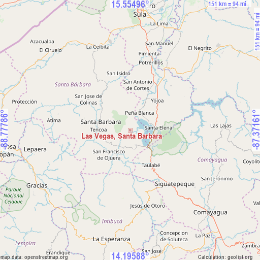
Las Vegas, Santa Barbara GPS coordinates[2]
14° 52' 35.364" North, 88° 4' 29.028" West
| Map corner | latitude | longitude |
|---|---|---|
| Upper-left | 15.55496°, | -88.77786° |
| Center: | 14.87649°, | -88.07473° |
| Lower-right: | 14.19588°, | -87.37161° |
| Map W x H: | 151.1×151.1 km | = 93.9×93.9mi |
| max Lat: | 16.45° ⇑50.4% North |
| Las Vegas, Santa Barbara: | 14.87649° |
| min Lat: | ⇓49.6% South 13.11667° |
| min Long | Las Vegas, Sant | max Long |
| -89.23333° | -88.07473° | -83.23333° |
| W 29.2%⇐ | ⇒70.8% E |
Elevation
Elevation of Las Vegas, Santa Barbara is 892 m = 2927 ft, and this is 330.8 m = 1085 ft above average elevation for this country.
| Max E: |
1811 m = 5942 ft | 22.2% |
| Las Vegas, Santa Barbara | 892 m 2927 ft | |
| Avg. | 561.2 m = 1841 ft | |
Min E: |
1 m = 3 ft | 77.8% |
See also: Honduras elevation on elevation.city.
Geographical zone
Las Vegas, Santa Barbara is located in North Torrid zone (between Equator and Tropic of Cancer). Distance of this Northern Tropic circle is 951.8 km =591.4 mi to North.| Distance of | km | miles | from Las Vegas, Santa Barbara |
|---|---|---|---|
| North Pole | 8353 | 5190.3 | to North |
| Arctic Circle | 5747.1 | 3571.1 | to North |
| Tropic Cancer | 951.8 | 591.4 | to North |
| Equator | 1654.1 | 1027.8 | to South |


Nearby cities:
15 places around Las Vegas, Santa Barbara: (largest is in red/bold)
• Agua Azul
12.4 km =7.7 mi,  68°
68°
• Agua Azul Rancho
13.7 km =8.5 mi,  78°
78°
• Cañaveral
13.4 km =8.3 mi,  27°
27°
• Ceguaca
15.9 km =9.9 mi,  237°
237°
• Concepción del Sur
13 km =8.1 mi,  229°
229°
• El Edén
10.3 km =6.4 mi,  37°
37°
• El Mochito
1.4 km =0.9 mi,  220°
220°
• El Tigre
11.7 km =7.3 mi,  57°
57°
• La Guama
15.2 km =9.4 mi,  87°
87°
• Los Caminos
14.2 km =8.8 mi,  54°
54°
• Los Naranjos
3.7 km =2.3 mi, 45°
• San José de Comayagua
16.5 km =10.3 mi,  164°
164°
• San Luis de Planes
13.4 km =8.3 mi,  332°
332°
• San Pedro Zacapa
14.8 km =9.2 mi,  197°
197°
• Santa Rita
15.9 km =9.9 mi,  286°
286°
Sources, notices
• [Note1] Compared only with cities in Honduras existing in our database
• [Src1] Map data: © OpenStreetMap contributors (CC-BY-SA)
• [Src2] Other city data from geonames.org with taken over terms of usage.
• [Src3] Geographical zone / Annual Mean Temperature by Robert A. Rohde @ Wikipedia
