Arizona geodata
Arizona (Atlántida) is a populated place; located in Honduras in America/Tegucigalpa (GMT-6) time zone. With population of 4,444 people, there are 72 cities with bigger population in this country. Compared to other cities in Honduras, 88.8% of cities are located further ↓South; 61% of cities are located further ←West and 80.6% of cities have higher elevation than Arizona. Note1


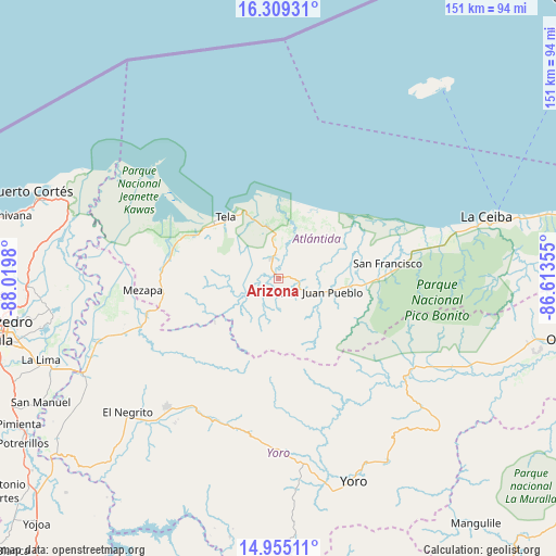
Arizona GPS coordinates[2]
15° 37' 59.988" North, 87° 19' 0.012" West
| Map corner | latitude | longitude |
|---|---|---|
| Upper-left | 16.30931°, | -88.0198° |
| Center: | 15.63333°, | -87.31667° |
| Lower-right: | 14.95511°, | -86.61355° |
| Map W x H: | 150.6×150.6 km | = 93.6×93.6mi |
| max Lat: | 16.45° ⇑11.2% North |
| Arizona: | 15.63333° |
| min Lat: | ⇓88.8% South 13.11667° |
| min Long | Arizona | max Long |
| -89.23333° | -87.31667° | -83.23333° |
| W 61%⇐ | ⇒39% E |
Elevation
Elevation of Arizona is 72 m = 236 ft, and this is 489.2 m = 1605 ft below average elevation for this country.
| Max E: |
1811 m = 5942 ft | 80.6% |
| Avg. | 561.2 m = 1841 ft | |
| Arizona | 72 m = 236 ft | |
Min E: |
1 m = 3 ft | 19.4% |
See also: Honduras elevation on elevation.city.
Geographical zone
Arizona is located in North Torrid zone (between Equator and Tropic of Cancer). Distance of this Northern Tropic circle is 867.7 km =539.2 mi to North.| Distance of | km | miles | from Arizona |
|---|---|---|---|
| North Pole | 8268.8 | 5138 | to North |
| Arctic Circle | 5662.9 | 3518.8 | to North |
| Tropic Cancer | 867.7 | 539.2 | to North |
| Equator | 1738.3 | 1080.1 | to South |


Nearby cities:
15 places around Arizona: (largest is in red/bold)
• Atenas de San Cristóbal
5.6 km =3.5 mi,  0°
0°
• El Triunfo de la Cruz
19.4 km =12.1 mi,  319°
319°
• Hicaque
10.7 km =6.6 mi,  329°
329°
• La Masica
21.5 km =13.4 mi,  94°
94°
• La Unión
35.1 km =21.8 mi,  74°
74°
• Matarras
15.7 km =9.8 mi,  214°
214°
• Mezapa
11.7 km =7.3 mi,  217°
217°
• Mezapa
36.1 km =22.4 mi,  261°
261°
• Nueva Florida
27 km =16.8 mi,  226°
226°
• San Antonio
18.2 km =11.3 mi,  101°
101°
• San Francisco
28.6 km =17.8 mi, 86°
• San Juan Pueblo
10.5 km =6.5 mi,  121°
121°
• Santa Ana
26.8 km =16.7 mi, 86°
• Tela
22.5 km =14 mi,  314°
314°
• Tornabé
28.1 km =17.5 mi,  297°
297°
Sources, notices
• [Note1] Compared only with cities in Honduras existing in our database
• [Src1] Map data: © OpenStreetMap contributors (CC-BY-SA)
• [Src2] Other city data from geonames.org with taken over terms of usage.
• [Src3] Geographical zone / Annual Mean Temperature by Robert A. Rohde @ Wikipedia
