Matarras geodata
Matarras (Atlántida) is a populated place; located in Honduras in America/Tegucigalpa (GMT-6) time zone. With population of 941 people, there are 457 cities with bigger population in this country. Compared to other cities in Honduras, 85.6% of cities are located further ↓South; 57.6% of cities are located further ←West and 53.4% of cities have higher elevation than Matarras. Note1


Matarras GPS coordinates[2]
15° 31' 0.012" North, 87° 24' 0" West
| Map corner | latitude | longitude |
|---|---|---|
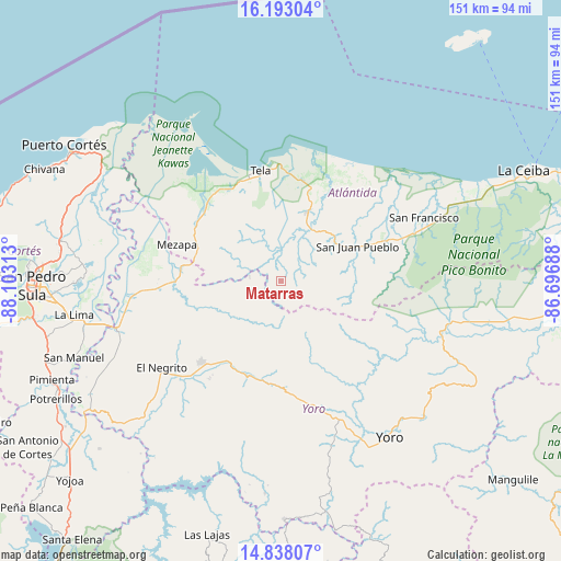
| Upper-left | 16.19304°, | -88.10313° |
| Center: | 15.51667°, | -87.4° |
| Lower-right: | 14.83807°, | -86.69688° |
| Map W x H: | 150.7×150.7 km | = 93.6×93.6mi |
| max Lat: | 16.45° ⇑14.4% North |
| Matarras: | 15.51667° |
| min Lat: | ⇓85.6% South 13.11667° |
| min Long | Matarras | max Long |
| -89.23333° | -87.4° | -83.23333° |
| W 57.6%⇐ | ⇒42.4% E |
Elevation
Elevation of Matarras is 512 m = 1680 ft, and this is 49.2 m = 161 ft below average elevation for this country.
| Max E: |
1811 m = 5942 ft | 53.4% |
| Avg. | 561.2 m = 1841 ft | |
| Matarras | 512 m = 1680 ft | |
Min E: |
1 m = 3 ft | 46.6% |
See also: Honduras elevation on elevation.city.
Geographical zone
Matarras is located in North Torrid zone (between Equator and Tropic of Cancer). Distance of this Northern Tropic circle is 880.6 km =547.2 mi to North.| Distance of | km | miles | from Matarras |
|---|---|---|---|
| North Pole | 8281.8 | 5146.1 | to North |
| Arctic Circle | 5675.9 | 3526.8 | to North |
| Tropic Cancer | 880.6 | 547.2 | to North |
| Equator | 1725.3 | 1072.1 | to South |


Nearby cities:
15 places around Matarras: (largest is in red/bold)
• Arizona
15.7 km =9.8 mi,  34°
34°
• Atenas de San Cristóbal
20.6 km =12.8 mi, 25°
• El Triunfo de la Cruz
28 km =17.4 mi,  352°
352°
• Hicaque
22.5 km =14 mi,  9°
9°
• La Estancia
30.5 km =19 mi,  211°
211°
• Mezapa
4.1 km =2.5 mi, 25°
• Mezapa
27.8 km =17.3 mi,  285°
285°
• Morazán
30.9 km =19.2 mi,  223°
223°
• Nueva Florida
12.1 km =7.5 mi,  242°
242°
• Ocote Paulino
24.1 km =15 mi, 242°
• San Antonio
28.3 km =17.6 mi,  70°
70°
• San Juan Pueblo
19.3 km =12 mi, 67°
• Tela
29.5 km =18.3 mi, 345°
• Tornabé
30.5 km =19 mi,  328°
328°
• Toyós
27 km =16.8 mi,  277°
277°
Sources, notices
• [Note1] Compared only with cities in Honduras existing in our database
• [Src1] Map data: © OpenStreetMap contributors (CC-BY-SA)
• [Src2] Other city data from geonames.org with taken over terms of usage.
• [Src3] Geographical zone / Annual Mean Temperature by Robert A. Rohde @ Wikipedia
