Tela geodata
Tela (Atlántida) is a populated place; located in Honduras in America/Tegucigalpa (GMT-6) time zone. With population of 29,325 people, there are 14 cities with bigger population in this country. Compared to other cities in Honduras, 95.4% of cities are located further ↓South; 55% of cities are located further ←West and 96% of cities have higher elevation than Tela. Note1


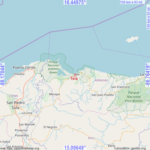
Tela GPS coordinates[2]
15° 46' 27.3" North, 87° 28' 2.316" West
| Map corner | latitude | longitude |
|---|---|---|
| Upper-left | 16.44975°, | -88.17044° |
| Center: | 15.77425°, | -87.46731° |
| Lower-right: | 15.09649°, | -86.76419° |
| Map W x H: | 150.5×150.5 km | = 93.5×93.5mi |
| max Lat: | 16.45° ⇑4.6% North |
| Tela: | 15.77425° |
| min Lat: | ⇓95.4% South 13.11667° |
| min Long | Tela | max Long |
| -89.23333° | -87.46731° | -83.23333° |
| W 55%⇐ | ⇒45% E |
Elevation
Elevation of Tela is 9 m = 30 ft, and this is 552.2 m = 1812 ft below average elevation for this country.
| Max E: |
1811 m = 5942 ft | 96% |
| Avg. | 561.2 m = 1841 ft | |
| Tela | 9 m = 30 ft | |
Min E: |
1 m = 3 ft | 4% |
See also: Honduras elevation on elevation.city.
Geographical zone
Tela is located in North Torrid zone (between Equator and Tropic of Cancer). Distance of this Northern Tropic circle is 852 km =529.4 mi to North.| Distance of | km | miles | from Tela |
|---|---|---|---|
| North Pole | 8253.1 | 5128.2 | to North |
| Arctic Circle | 5647.2 | 3509 | to North |
| Tropic Cancer | 852 | 529.4 | to North |
| Equator | 1753.9 | 1089.8 | to South |


Nearby cities:
15 places around Tela: (largest is in red/bold)
• Arizona
22.5 km =14 mi,  134°
134°
• Atenas de San Cristóbal
19 km =11.8 mi,  122°
122°
• Baracoa
41 km =25.5 mi,  268°
268°
• El Triunfo de la Cruz
3.7 km =2.3 mi,  103°
103°
• Guaimitas
40.5 km =25.2 mi,  221°
221°
• Hicaque
12.5 km =7.8 mi, 120°
• La Masica
41.4 km =25.7 mi, 115°
• Matarras
29.5 km =18.3 mi,  165°
165°
• Mezapa
26.5 km =16.5 mi,  160°
160°
• Mezapa
28.9 km =18 mi, 222°
• Nueva Florida
34.4 km =21.4 mi,  185°
185°
• San Antonio
39.1 km =24.3 mi, 119°
• San Juan Pueblo
32.8 km =20.4 mi, 130°
• Tornabé
9.3 km =5.8 mi,  253°
253°
• Toyós
31.7 km =19.7 mi, 218°
Sources, notices
• [Note1] Compared only with cities in Honduras existing in our database
• [Src1] Map data: © OpenStreetMap contributors (CC-BY-SA)
• [Src2] Other city data from geonames.org with taken over terms of usage.
• [Src3] Geographical zone / Annual Mean Temperature by Robert A. Rohde @ Wikipedia
