Mezapa geodata
Mezapa (Atlántida) is a populated place; located in Honduras in America/Tegucigalpa (GMT-6) time zone. With population of 6,324 people, there are 51 cities with bigger population in this country. Compared to other cities in Honduras, 87% of cities are located further ↓South; 51% of cities are located further →East and 74.6% of cities have higher elevation than Mezapa. Note1


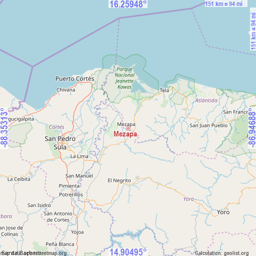
Mezapa GPS coordinates[2]
15° 34' 59.988" North, 87° 39' 0" West
| Map corner | latitude | longitude |
|---|---|---|
| Upper-left | 16.25948°, | -88.35313° |
| Center: | 15.58333°, | -87.65° |
| Lower-right: | 14.90495°, | -86.94688° |
| Map W x H: | 150.6×150.6 km | = 93.6×93.6mi |
| max Lat: | 16.45° ⇑13% North |
| Mezapa: | 15.58333° |
| min Lat: | ⇓87% South 13.11667° |
| min Long | Mezapa | max Long |
| -89.23333° | -87.65° | -83.23333° |
| W 49%⇐ | ⇒51% E |
Elevation
Elevation of Mezapa is 154 m = 505 ft, and this is 407.2 m = 1336 ft below average elevation for this country.
| Max E: |
1811 m = 5942 ft | 74.6% |
| Avg. | 561.2 m = 1841 ft | |
| Mezapa | 154 m = 505 ft | |
Min E: |
1 m = 3 ft | 25.4% |
See also: Honduras elevation on elevation.city.
Geographical zone
Mezapa is located in North Torrid zone (between Equator and Tropic of Cancer). Distance of this Northern Tropic circle is 873.2 km =542.6 mi to North.| Distance of | km | miles | from Mezapa |
|---|---|---|---|
| North Pole | 8274.4 | 5141.5 | to North |
| Arctic Circle | 5668.5 | 3522.2 | to North |
| Tropic Cancer | 873.2 | 542.6 | to North |
| Equator | 1732.7 | 1076.6 | to South |


Nearby cities:
15 places around Mezapa: (largest is in red/bold)
• El Progreso
26 km =16.2 mi,  218°
218°
• Guaimitas
11.7 km =7.3 mi, 217°
• La Huesa
25 km =15.5 mi,  270°
270°
• Matarras
27.8 km =17.3 mi,  105°
105°
• Mezapa
28.8 km =17.9 mi,  97°
97°
• Monterrey
25 km =15.5 mi, 270°
• Nueva Florida
20.7 km =12.9 mi,  128°
128°
• Ocote Paulino
19.3 km =12 mi,  163°
163°
• Puerto Alto
26.6 km =16.5 mi,  299°
299°
• Quebrada de Yoro
22 km =13.7 mi, 220°
• San José del Boquerón
25.7 km =16 mi,  244°
244°
• Tela
28.9 km =18 mi,  42°
42°
• Tornabé
21.4 km =13.3 mi,  30°
30°
• Toyós
3.7 km =2.3 mi,  180°
180°
• Victoria
20.8 km =12.9 mi, 244°
Sources, notices
• [Note1] Compared only with cities in Honduras existing in our database
• [Src1] Map data: © OpenStreetMap contributors (CC-BY-SA)
• [Src2] Other city data from geonames.org with taken over terms of usage.
• [Src3] Geographical zone / Annual Mean Temperature by Robert A. Rohde @ Wikipedia
