Vukosavljevica geodata
Vukosavljevica (Virovitičk-Podravska) is a populated place; located in Croatia in Europe/Zagreb (GMT+2) time zone. With population of 679 people, there are 684 cities with bigger population in this country. Compared to other cities in Croatia, 75.9% of cities are located further ↓South; 72.5% of cities are located further ←West and 66.9% of cities have lower elevation than Vukosavljevica. Note1


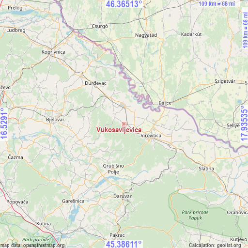
Vukosavljevica GPS coordinates[2]
45° 52' 40.008" North, 17° 13' 55.992" East
| Map corner | latitude | longitude |
|---|---|---|
| Upper-left | 46.36513°, | 16.5291° |
| Center: | 45.87778°, | 17.23222° |
| Lower-right: | 45.38611°, | 17.93535° |
| Map W x H: | 108.9×108.9 km | = 67.7×67.7mi |
| max Lat: | 46.52694° ⇑24.1% North |
| Vukosavljevica: | 45.87778° |
| min Lat: | ⇓75.9% South 42.54972° |
| min Long | Vukosavljevica | max Long |
| 13.52389° | 17.23222° | 19.37694° |
| W 72.5%⇐ | ⇒27.5% E |
Elevation
Elevation of Vukosavljevica is 158 m = 518 ft, and this is 4.7 m = 15 ft above average elevation for this country.
| Max E: |
827 m = 2713 ft | 33.1% |
| Vukosavljevica | 158 m 518 ft | |
| Avg. | 153.3 m = 503 ft | |
Min E: |
-1 m = -3 ft | 66.9% |
See also: Croatia elevation on elevation.city.
Geographical zone
Vukosavljevica is located in North temperate zone (between Tropic of Cancer and the Arctic Circle). Distance of this North polar circle is 2300 km =1429.2 mi to North.| Distance of | km | miles | from Vukosavljevica |
|---|---|---|---|
| North Pole | 4905.9 | 3048.4 | to North |
| Arctic Circle | 2300 | 1429.2 | to North |
| Tropic Cancer | 2495.2 | 1550.4 | to South |
| Equator | 5101.1 | 3169.7 | to South |


Nearby cities:
15 places around Vukosavljevica: (largest is in red/bold)
• Budančevica
13.3 km =8.3 mi,  331°
331°
• Bušetina
9.8 km =6.1 mi,  77°
77°
• Kloštar Podravski
12.9 km =8 mi, 332°
• Kozarevac
10.6 km =6.6 mi,  302°
302°
• Lukač
14.5 km =9 mi,  92°
92°
• Otrovanec
5.4 km =3.4 mi,  337°
337°
• Pitomača
8.1 km =5 mi,  358°
358°
• Podravske Sesvete
14.2 km =8.8 mi,  353°
353°
• Prugovac
13.5 km =8.4 mi,  319°
319°
• Stari Gradac
6.9 km =4.3 mi,  41°
41°
• Turanovac
12.8 km =8 mi, 82°
• Velika Pisanica
15.4 km =9.6 mi,  236°
236°
• Velika Črešnjevica
5.1 km =3.2 mi,  308°
308°
• Virovitica
12.8 km =8 mi,  113°
113°
• Špišić-Bukovica
5.7 km =3.5 mi, 113°
Sources, notices
• [Note1] Compared only with cities in Croatia existing in our database
• [Src1] Map data: © OpenStreetMap contributors (CC-BY-SA)
• [Src2] Other city data from geonames.org with taken over terms of usage.
• [Src3] Geographical zone / Annual Mean Temperature by Robert A. Rohde @ Wikipedia
