Otrovanec geodata
Otrovanec (Virovitičk-Podravska) is a populated place; located in Croatia in Europe/Zagreb (GMT+2) time zone. With population of 624 people, there are 729 cities with bigger population in this country. Compared to other cities in Croatia, 78.7% of cities are located further ↓South; 71.9% of cities are located further ←West and 51.7% of cities have higher elevation than Otrovanec. Note1


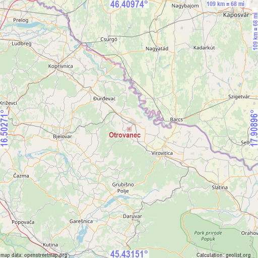
Otrovanec GPS coordinates[2]
45° 55' 22.008" North, 17° 12' 20.988" East
| Map corner | latitude | longitude |
|---|---|---|
| Upper-left | 46.40974°, | 16.50271° |
| Center: | 45.92278°, | 17.20583° |
| Lower-right: | 45.43151°, | 17.90896° |
| Map W x H: | 108.8×108.8 km | = 67.6×67.6mi |
| max Lat: | 46.52694° ⇑21.3% North |
| Otrovanec: | 45.92278° |
| min Lat: | ⇓78.7% South 42.54972° |
| min Long | Otrovanec | max Long |
| 13.52389° | 17.20583° | 19.37694° |
| W 71.9%⇐ | ⇒28.1% E |
Elevation
Elevation of Otrovanec is 124 m = 407 ft, and this is 29.3 m = 96 ft below average elevation for this country.
| Max E: |
827 m = 2713 ft | 51.7% |
| Avg. | 153.3 m = 503 ft | |
| Otrovanec | 124 m = 407 ft | |
Min E: |
-1 m = -3 ft | 48.3% |
See also: Croatia elevation on elevation.city.
Geographical zone
Otrovanec is located in North temperate zone (between Tropic of Cancer and the Arctic Circle). Distance of this North polar circle is 2295 km =1426 mi to North.| Distance of | km | miles | from Otrovanec |
|---|---|---|---|
| North Pole | 4900.9 | 3045.3 | to North |
| Arctic Circle | 2295 | 1426 | to North |
| Tropic Cancer | 2500.2 | 1553.6 | to South |
| Equator | 5106.1 | 3172.8 | to South |


Nearby cities:
15 places around Otrovanec: (largest is in red/bold)
• Budančevica
8 km =5 mi,  327°
327°
• Bušetina
11.9 km =7.4 mi,  103°
103°
• Ferdinandovac
14.2 km =8.8 mi,  358°
358°
• Kalinovac
13.8 km =8.6 mi, 329°
• Kloštar Podravski
7.6 km =4.7 mi, 329°
• Kozarevac
6.9 km =4.3 mi,  275°
275°
• Pitomača
3.6 km =2.2 mi,  30°
30°
• Podravske Sesvete
9.2 km =5.7 mi,  2°
2°
• Prugovac
8.5 km =5.3 mi,  308°
308°
• Stari Gradac
6.6 km =4.1 mi,  88°
88°
• Turanovac
15 km =9.3 mi, 102°
• Velika Črešnjevica
2.6 km =1.6 mi,  227°
227°
• Vukosavljevica
5.4 km =3.4 mi,  157°
157°
• Šandrovac
14.4 km =8.9 mi,  262°
262°
• Špišić-Bukovica
10.3 km =6.4 mi,  135°
135°
Sources, notices
• [Note1] Compared only with cities in Croatia existing in our database
• [Src1] Map data: © OpenStreetMap contributors (CC-BY-SA)
• [Src2] Other city data from geonames.org with taken over terms of usage.
• [Src3] Geographical zone / Annual Mean Temperature by Robert A. Rohde @ Wikipedia
