Umag geodata
Umag (Istria) is a seat of a second-order administrative division; located in Croatia in Europe/Zagreb (GMT+2) time zone. With population of 7,807 people, there are 51 cities with bigger population in this country. Compared to other cities in Croatia, 50.2% of cities are located further ↓South; 100% of cities are located further →East and 98.2% of cities have higher elevation than Umag. Note1


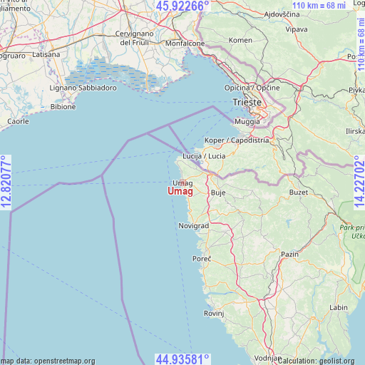
Umag GPS coordinates[2]
45° 25' 53.004" North, 13° 31' 26.004" East
| Map corner | latitude | longitude |
|---|---|---|
| Upper-left | 45.92266°, | 12.82077° |
| Center: | 45.43139°, | 13.52389° |
| Lower-right: | 44.93581°, | 14.22702° |
| Map W x H: | 109.7×109.7 km | = 68.2×68.2mi |
| max Lat: | 46.52694° ⇑49.8% North |
| Umag: | 45.43139° |
| min Lat: | ⇓50.2% South 42.54972° |
| min Long | Umag | max Long |
| 13.52389° | 13.52389° | 19.37694° |
| W 0%⇐ | ⇒100% E |
Elevation
Elevation of Umag is 4 m = 13 ft, and this is 149.3 m = 490 ft below average elevation for this country.
| Max E: |
827 m = 2713 ft | 98.2% |
| Avg. | 153.3 m = 503 ft | |
| Umag | 4 m = 13 ft | |
Min E: |
-1 m = -3 ft | 1.8% |
See also: Croatia elevation on elevation.city.
Geographical zone
Umag is located in North temperate zone (between Tropic of Cancer and the Arctic Circle). Distance of this North polar circle is 2349.7 km =1460 mi to North.| Distance of | km | miles | from Umag |
|---|---|---|---|
| North Pole | 4955.6 | 3079.3 | to North |
| Arctic Circle | 2349.7 | 1460 | to North |
| Tropic Cancer | 2445.6 | 1519.6 | to South |
| Equator | 5051.5 | 3138.9 | to South |


Nearby cities:
15 places around Umag: (largest is in red/bold)
• Brtonigla
9.9 km =6.2 mi,  124°
124°
• Buje
11 km =6.8 mi,  102°
102°
• Funtana
29.2 km =18.1 mi,  167°
167°
• Grožnjan
16.7 km =10.4 mi,  110°
110°
• Karojba
27.5 km =17.1 mi, 121°
• Kaštelir
19 km =11.8 mi,  138°
138°
• Motovun
26 km =16.2 mi, 113°
• Novigrad
13.2 km =8.2 mi, 168°
• Oprtalj
24.2 km =15 mi, 103°
• Poreč
23.5 km =14.6 mi, 166°
• Tar
16.5 km =10.3 mi,  151°
151°
• Visignano
23.1 km =14.4 mi, 138°
• Vižinada
21.6 km =13.4 mi, 121°
• Vrvari
24.6 km =15.3 mi,  159°
159°
• Červar-Porat
18.6 km =11.6 mi, 162°
Sources, notices
• [Note1] Compared only with cities in Croatia existing in our database
• [Src1] Map data: © OpenStreetMap contributors (CC-BY-SA)
• [Src2] Other city data from geonames.org with taken over terms of usage.
• [Src3] Geographical zone / Annual Mean Temperature by Robert A. Rohde @ Wikipedia
