Buje geodata
Buje (Istria) is a seat of a second-order administrative division; located in Croatia in Europe/Zagreb (GMT+2) time zone. With population of 3,016 people, there are 138 cities with bigger population in this country. Compared to other cities in Croatia, 50.8% of cities are located further ↑North; 99.1% of cities are located further →East and 78.9% of cities have lower elevation than Buje. Note1


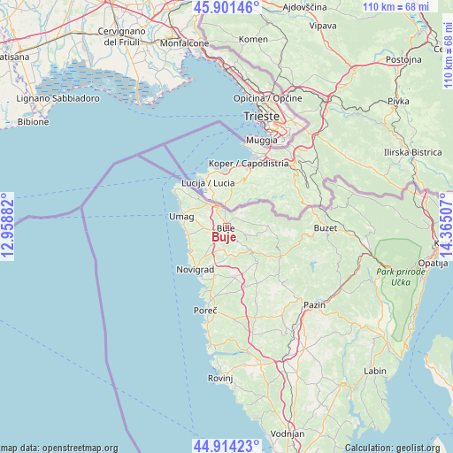
Buje GPS coordinates[2]
45° 24' 36" North, 13° 39' 42.984" East
| Map corner | latitude | longitude |
|---|---|---|
| Upper-left | 45.90146°, | 12.95882° |
| Center: | 45.41°, | 13.66194° |
| Lower-right: | 44.91423°, | 14.36507° |
| Map W x H: | 109.8×109.8 km | = 68.2×68.2mi |
| max Lat: | 46.52694° ⇑50.8% North |
| Buje: | 45.41° |
| min Lat: | ⇓49.2% South 42.54972° |
| min Long | Buje | max Long |
| 13.52389° | 13.66194° | 19.37694° |
| W 0.9%⇐ | ⇒99.1% E |
Elevation
Elevation of Buje is 197 m = 646 ft, and this is 43.7 m = 143 ft above average elevation for this country.
| Max E: |
827 m = 2713 ft | 21.1% |
| Buje | 197 m 646 ft | |
| Avg. | 153.3 m = 503 ft | |
Min E: |
-1 m = -3 ft | 78.9% |
See also: Croatia elevation on elevation.city.
Geographical zone
Buje is located in North temperate zone (between Tropic of Cancer and the Arctic Circle). Distance of this North polar circle is 2352.1 km =1461.5 mi to North.| Distance of | km | miles | from Buje |
|---|---|---|---|
| North Pole | 4957.9 | 3080.7 | to North |
| Arctic Circle | 2352.1 | 1461.5 | to North |
| Tropic Cancer | 2443.2 | 1518.1 | to South |
| Equator | 5049.1 | 3137.4 | to South |


Nearby cities:
15 places around Buje: (largest is in red/bold)
• Brtonigla
4.1 km =2.5 mi,  218°
218°
• Buzet
23.8 km =14.8 mi,  90°
90°
• Grožnjan
5.9 km =3.7 mi,  125°
125°
• Karojba
17.5 km =10.9 mi, 133°
• Kaštelir
12 km =7.5 mi,  171°
171°
• Motovun
15.4 km =9.6 mi,  122°
122°
• Novigrad
13.3 km =8.3 mi, 217°
• Oprtalj
13.2 km =8.2 mi,  103°
103°
• Poreč
21.2 km =13.2 mi,  194°
194°
• Tar
12.5 km =7.8 mi, 193°
• Umag
11 km =6.8 mi,  282°
282°
• Visignano
15.6 km =9.7 mi,  162°
162°
• Vižinada
11.7 km =7.3 mi,  139°
139°
• Vrvari
20.7 km =12.9 mi, 185°
• Červar-Porat
16.2 km =10.1 mi,  198°
198°
Sources, notices
• [Note1] Compared only with cities in Croatia existing in our database
• [Src1] Map data: © OpenStreetMap contributors (CC-BY-SA)
• [Src2] Other city data from geonames.org with taken over terms of usage.
• [Src3] Geographical zone / Annual Mean Temperature by Robert A. Rohde @ Wikipedia
