Tugonica geodata
Tugonica (Krapinsko-Zagorska) is a populated place; located in Croatia in Europe/Zagreb (GMT+2) time zone. With population of 578 people, there are 774 cities with bigger population in this country. Compared to other cities in Croatia, 82.9% of cities are located further ↓South; 65.4% of cities are located further →East and 70.6% of cities have lower elevation than Tugonica. Note1


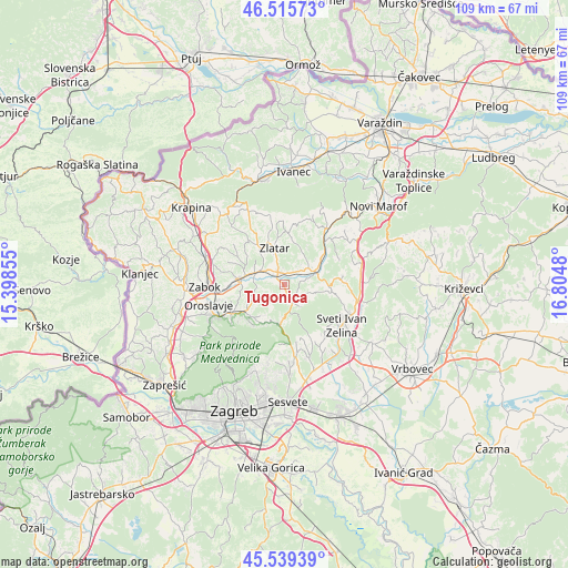
Tugonica GPS coordinates[2]
46° 1' 46.992" North, 16° 6' 6.012" East
| Map corner | latitude | longitude |
|---|---|---|
| Upper-left | 46.51573°, | 15.39855° |
| Center: | 46.02972°, | 16.10167° |
| Lower-right: | 45.53939°, | 16.8048° |
| Map W x H: | 108.6×108.6 km | = 67.5×67.5mi |
| max Lat: | 46.52694° ⇑17.1% North |
| Tugonica: | 46.02972° |
| min Lat: | ⇓82.9% South 42.54972° |
| min Long | Tugonica | max Long |
| 13.52389° | 16.10167° | 19.37694° |
| W 34.6%⇐ | ⇒65.4% E |
Elevation
Elevation of Tugonica is 168 m = 551 ft, and this is 14.7 m = 48 ft above average elevation for this country.
| Max E: |
827 m = 2713 ft | 29.4% |
| Tugonica | 168 m 551 ft | |
| Avg. | 153.3 m = 503 ft | |
Min E: |
-1 m = -3 ft | 70.6% |
See also: Croatia elevation on elevation.city.
Geographical zone
Tugonica is located in North temperate zone (between Tropic of Cancer and the Arctic Circle). Distance of this North polar circle is 2283.1 km =1418.7 mi to North.| Distance of | km | miles | from Tugonica |
|---|---|---|---|
| North Pole | 4889 | 3037.9 | to North |
| Arctic Circle | 2283.1 | 1418.7 | to North |
| Tropic Cancer | 2512.1 | 1560.9 | to South |
| Equator | 5118 | 3180.2 | to South |


Nearby cities:
15 places around Tugonica: (largest is in red/bold)
• Bedekovčina
8.2 km =5.1 mi,  278°
278°
• Bedenica
10.9 km =6.8 mi,  87°
87°
• Donja Stubica
11.6 km =7.2 mi,  243°
243°
• Donje Orešje
11.9 km =7.4 mi,  106°
106°
• Gornja Stubica
8.8 km =5.5 mi,  226°
226°
• Hum Stubički
2.7 km =1.7 mi,  200°
200°
• Jertovec
6.7 km =4.2 mi,  80°
80°
• Konjšćina
6 km =3.7 mi,  65°
65°
• Laz Bistrički
7 km =4.3 mi,  181°
181°
• Marija Bistrica
2.7 km =1.7 mi,  164°
164°
• Mače
8.9 km =5.5 mi,  324°
324°
• Poznanovec
6.1 km =3.8 mi,  292°
292°
• Selnica
4.4 km =2.7 mi,  264°
264°
• Sveti Matej
7.5 km =4.7 mi, 201°
• Zlatar
7.6 km =4.7 mi,  341°
341°
Sources, notices
• [Note1] Compared only with cities in Croatia existing in our database
• [Src1] Map data: © OpenStreetMap contributors (CC-BY-SA)
• [Src2] Other city data from geonames.org with taken over terms of usage.
• [Src3] Geographical zone / Annual Mean Temperature by Robert A. Rohde @ Wikipedia
