Selnica geodata
Selnica (Krapinsko-Zagorska) is a populated place; located in Croatia in Europe/Zagreb (GMT+2) time zone. With population of 653 people, there are 706 cities with bigger population in this country. Compared to other cities in Croatia, 82.6% of cities are located further ↓South; 67.7% of cities are located further →East and 66.9% of cities have lower elevation than Selnica. Note1


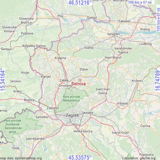
Selnica GPS coordinates[2]
46° 1' 33.996" North, 16° 2' 41.136" East
| Map corner | latitude | longitude |
|---|---|---|
| Upper-left | 46.51216°, | 15.34164° |
| Center: | 46.02611°, | 16.04476° |
| Lower-right: | 45.53575°, | 16.74789° |
| Map W x H: | 108.6×108.6 km | = 67.5×67.5mi |
| max Lat: | 46.52694° ⇑17.4% North |
| Selnica: | 46.02611° |
| min Lat: | ⇓82.6% South 42.54972° |
| min Long | Selnica | max Long |
| 13.52389° | 16.04476° | 19.37694° |
| W 32.3%⇐ | ⇒67.7% E |
Elevation
Elevation of Selnica is 158 m = 518 ft, and this is 4.7 m = 15 ft above average elevation for this country.
| Max E: |
827 m = 2713 ft | 33.1% |
| Selnica | 158 m 518 ft | |
| Avg. | 153.3 m = 503 ft | |
Min E: |
-1 m = -3 ft | 66.9% |
See also: Croatia elevation on elevation.city.
Geographical zone
Selnica is located in North temperate zone (between Tropic of Cancer and the Arctic Circle). Distance of this North polar circle is 2283.6 km =1419 mi to North.| Distance of | km | miles | from Selnica |
|---|---|---|---|
| North Pole | 4889.4 | 3038.1 | to North |
| Arctic Circle | 2283.6 | 1419 | to North |
| Tropic Cancer | 2511.7 | 1560.7 | to South |
| Equator | 5117.6 | 3179.9 | to South |


Nearby cities:
15 places around Selnica: (largest is in red/bold)
• Andraševec
8.9 km =5.5 mi,  241°
241°
• Bedekovčina
4.1 km =2.5 mi,  294°
294°
• Donja Stubica
7.7 km =4.8 mi,  231°
231°
• Gornja Stubica
6 km =3.7 mi,  199°
199°
• Hum Stubički
4.1 km =2.5 mi,  122°
122°
• Konjšćina
10.3 km =6.4 mi,  73°
73°
• Laz Bistrički
7.9 km =4.9 mi,  147°
147°
• Marija Bistrica
5.6 km =3.5 mi,  113°
113°
• Mače
7.7 km =4.8 mi,  354°
354°
• Poznanovec
3 km =1.9 mi,  335°
335°
• Pustodol
9.1 km =5.7 mi, 225°
• Sveti Matej
6.8 km =4.2 mi,  165°
165°
• Tugonica
4.4 km =2.7 mi,  84°
84°
• Zabok
10 km =6.2 mi,  272°
272°
• Zlatar
7.8 km =4.8 mi,  14°
14°
Sources, notices
• [Note1] Compared only with cities in Croatia existing in our database
• [Src1] Map data: © OpenStreetMap contributors (CC-BY-SA)
• [Src2] Other city data from geonames.org with taken over terms of usage.
• [Src3] Geographical zone / Annual Mean Temperature by Robert A. Rohde @ Wikipedia
