Sveti Matej geodata
Sveti Matej (Krapinsko-Zagorska) is a populated place; located in Croatia in Europe/Zagreb (GMT+2) time zone. With population of 579 people, there are 773 cities with bigger population in this country. Compared to other cities in Croatia, 80.4% of cities are located further ↓South; 67.1% of cities are located further →East and 87.3% of cities have lower elevation than Sveti Matej. Note1


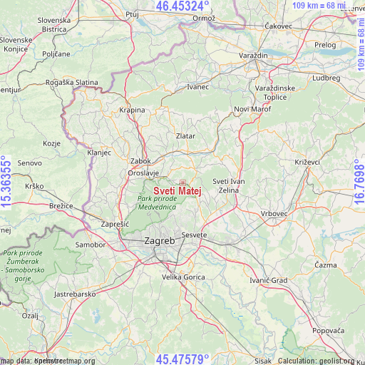
Sveti Matej GPS coordinates[2]
45° 58' 0.012" North, 16° 4' 0.012" East
| Map corner | latitude | longitude |
|---|---|---|
| Upper-left | 46.45324°, | 15.36355° |
| Center: | 45.96667°, | 16.06667° |
| Lower-right: | 45.47579°, | 16.7698° |
| Map W x H: | 108.7×108.7 km | = 67.5×67.5mi |
| max Lat: | 46.52694° ⇑19.6% North |
| Sveti Matej: | 45.96667° |
| min Lat: | ⇓80.4% South 42.54972° |
| min Long | Sveti Matej | max Long |
| 13.52389° | 16.06667° | 19.37694° |
| W 32.9%⇐ | ⇒67.1% E |
Elevation
Elevation of Sveti Matej is 260 m = 853 ft, and this is 106.7 m = 350 ft above average elevation for this country.
| Max E: |
827 m = 2713 ft | 12.7% |
| Sveti Matej | 260 m 853 ft | |
| Avg. | 153.3 m = 503 ft | |
Min E: |
-1 m = -3 ft | 87.3% |
See also: Croatia elevation on elevation.city.
Geographical zone
Sveti Matej is located in North temperate zone (between Tropic of Cancer and the Arctic Circle). Distance of this North polar circle is 2290.2 km =1423.1 mi to North.| Distance of | km | miles | from Sveti Matej |
|---|---|---|---|
| North Pole | 4896 | 3042.2 | to North |
| Arctic Circle | 2290.2 | 1423.1 | to North |
| Tropic Cancer | 2505.1 | 1556.6 | to South |
| Equator | 5111 | 3175.8 | to South |


Nearby cities:
15 places around Sveti Matej: (largest is in red/bold)
• Adamovec
10.2 km =6.3 mi,  132°
132°
• Andraševec
9.8 km =6.1 mi,  283°
283°
• Bedekovčina
9.9 km =6.2 mi,  326°
326°
• Donja Stubica
7.9 km =4.9 mi, 283°
• Gornja Stubica
3.8 km =2.4 mi, 284°
• Hum Stubički
4.8 km =3 mi,  21°
21°
• Kašina
7.6 km =4.7 mi,  144°
144°
• Laz Bistrički
2.6 km =1.6 mi,  90°
90°
• Marija Bistrica
5.6 km =3.5 mi,  38°
38°
• Oroslavje
12.2 km =7.6 mi,  285°
285°
• Poznanovec
9.8 km =6.1 mi,  342°
342°
• Pustodol
8.2 km =5.1 mi,  271°
271°
• Selnica
6.8 km =4.2 mi,  345°
345°
• Stubičke Toplice
10.4 km =6.5 mi, 275°
• Tugonica
7.5 km =4.7 mi, 21°
Sources, notices
• [Note1] Compared only with cities in Croatia existing in our database
• [Src1] Map data: © OpenStreetMap contributors (CC-BY-SA)
• [Src2] Other city data from geonames.org with taken over terms of usage.
• [Src3] Geographical zone / Annual Mean Temperature by Robert A. Rohde @ Wikipedia
