Trema geodata
Trema (Koprivničko-Križevačka) is a populated place; located in Croatia in Europe/Zagreb (GMT+2) time zone. With population of 786 people, there are 611 cities with bigger population in this country. Compared to other cities in Croatia, 81.4% of cities are located further ↓South; 56.2% of cities are located further ←West and 73.9% of cities have lower elevation than Trema. Note1


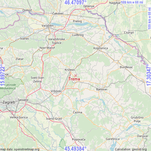
Trema GPS coordinates[2]
45° 59' 4.416" North, 16° 36' 1.224" East
| Map corner | latitude | longitude |
|---|---|---|
| Upper-left | 46.47097°, | 15.89722° |
| Center: | 45.98456°, | 16.60034° |
| Lower-right: | 45.49384°, | 17.30347° |
| Map W x H: | 108.6×108.6 km | = 67.5×67.5mi |
| max Lat: | 46.52694° ⇑18.6% North |
| Trema: | 45.98456° |
| min Lat: | ⇓81.4% South 42.54972° |
| min Long | Trema | max Long |
| 13.52389° | 16.60034° | 19.37694° |
| W 56.2%⇐ | ⇒43.8% E |
Elevation
Elevation of Trema is 176 m = 577 ft, and this is 22.7 m = 74 ft above average elevation for this country.
| Max E: |
827 m = 2713 ft | 26.1% |
| Trema | 176 m 577 ft | |
| Avg. | 153.3 m = 503 ft | |
Min E: |
-1 m = -3 ft | 73.9% |
See also: Croatia elevation on elevation.city.
Geographical zone
Trema is located in North temperate zone (between Tropic of Cancer and the Arctic Circle). Distance of this North polar circle is 2288.2 km =1421.8 mi to North.| Distance of | km | miles | from Trema |
|---|---|---|---|
| North Pole | 4894.1 | 3041.1 | to North |
| Arctic Circle | 2288.2 | 1421.8 | to North |
| Tropic Cancer | 2507.1 | 1557.8 | to South |
| Equator | 5113 | 3177.1 | to South |


Nearby cities:
15 places around Trema: (largest is in red/bold)
• Cirkvena
7.5 km =4.7 mi,  141°
141°
• Cubinec
2.6 km =1.6 mi,  266°
266°
• Farkaševac
12.1 km =7.5 mi,  165°
165°
• Gradec
12.2 km =7.6 mi,  228°
228°
• Haganj
8.4 km =5.2 mi,  189°
189°
• Klokočevac
16 km =9.9 mi,  118°
118°
• Križevci
6.1 km =3.8 mi,  312°
312°
• Pavlovec Gradečki
13 km =8.1 mi,  223°
223°
• Predavac
15.1 km =9.4 mi,  110°
110°
• Prgomelje
15.7 km =9.8 mi,  131°
131°
• Rovišće
11.3 km =7 mi, 113°
• Sokolovac
16.3 km =10.1 mi,  30°
30°
• Sveti Ivan Žabno
4.4 km =2.7 mi, 166°
• Sveti Petar Orehovec
15.3 km =9.5 mi, 311°
• Sveti Petar Čvrstec
5.4 km =3.4 mi,  68°
68°
Sources, notices
• [Note1] Compared only with cities in Croatia existing in our database
• [Src1] Map data: © OpenStreetMap contributors (CC-BY-SA)
• [Src2] Other city data from geonames.org with taken over terms of usage.
• [Src3] Geographical zone / Annual Mean Temperature by Robert A. Rohde @ Wikipedia
