Gospić geodata
Gospić (Ličko-Senjska) is a seat of a first-order administrative division; located in Croatia in Europe/Zagreb (GMT+2) time zone. With population of 6,118 people, there are 65 cities with bigger population in this country. Compared to other cities in Croatia, 79.1% of cities are located further ↑North; 84.9% of cities are located further →East and 98.1% of cities have lower elevation than Gospić. Note1


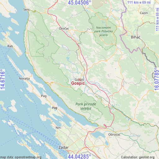
Gospić GPS coordinates[2]
44° 32' 45.996" North, 15° 22' 28.992" East
| Map corner | latitude | longitude |
|---|---|---|
| Upper-left | 45.04506°, | 14.6716° |
| Center: | 44.54611°, | 15.37472° |
| Lower-right: | 44.04285°, | 16.07785° |
| Map W x H: | 111.4×111.4 km | = 69.2×69.2mi |
| max Lat: | 46.52694° ⇑79.1% North |
| Gospić: | 44.54611° |
| min Lat: | ⇓20.9% South 42.54972° |
| min Long | Gospić | max Long |
| 13.52389° | 15.37472° | 19.37694° |
| W 15.1%⇐ | ⇒84.9% E |
Elevation
Elevation of Gospić is 563 m = 1847 ft, and this is 409.7 m = 1344 ft above average elevation for this country.
| Max E: |
827 m = 2713 ft | 1.9% |
| Gospić | 563 m 1847 ft | |
| Avg. | 153.3 m = 503 ft | |
Min E: |
-1 m = -3 ft | 98.1% |
See also: Croatia elevation on elevation.city.
Geographical zone
Gospić is located in North temperate zone (between Tropic of Cancer and the Arctic Circle). Distance of this Northern Tropic circle is 2347.1 km =1458.4 mi to South.| Distance of | km | miles | from Gospić |
|---|---|---|---|
| North Pole | 5054 | 3140.4 | to North |
| Arctic Circle | 2448.1 | 1521.2 | to North |
| Tropic Cancer | 2347.1 | 1458.4 | to South |
| Equator | 4953.1 | 3077.7 | to South |


Nearby cities:
15 places around Gospić: (largest is in red/bold)
• Karlobag
23.9 km =14.9 mi,  265°
265°
• Lički Osik
7.5 km =4.7 mi,  31°
31°
• Ličko Lešće
29 km =18 mi,  352°
352°
• Lovinac
30.1 km =18.7 mi,  124°
124°
• Pag
27.6 km =17.1 mi,  245°
245°
• Perušić
11.5 km =7.1 mi,  3°
3°
• Popovača
18.6 km =11.6 mi,  303°
303°
• Povljana
30.2 km =18.8 mi,  222°
222°
• Ražanac
29.4 km =18.3 mi,  184°
184°
• Sinac
31.7 km =19.7 mi, 353°
• Stari Grad
27.9 km =17.3 mi,  242°
242°
• Starigrad
28.3 km =17.6 mi,  169°
169°
• Udbina
31 km =19.3 mi,  93°
93°
• Vrsi
33.3 km =20.7 mi,  199°
199°
• Čovići
31.9 km =19.8 mi, 349°
Sources, notices
• [Note1] Compared only with cities in Croatia existing in our database
• [Src1] Map data: © OpenStreetMap contributors (CC-BY-SA)
• [Src2] Other city data from geonames.org with taken over terms of usage.
• [Src3] Geographical zone / Annual Mean Temperature by Robert A. Rohde @ Wikipedia
