Medulin geodata
Medulin (Istria) is a seat of a second-order administrative division; located in Croatia in Europe/Zagreb (GMT+2) time zone. With population of 2,593 people, there are 167 cities with bigger population in this country. Compared to other cities in Croatia, 77.8% of cities are located further ↑North; 96.9% of cities are located further →East and 93.3% of cities have higher elevation than Medulin. Note1


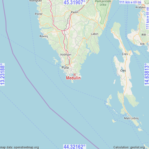
Medulin GPS coordinates[2]
44° 49' 21" North, 13° 56' 6" East
| Map corner | latitude | longitude |
|---|---|---|
| Upper-left | 45.31907°, | 13.23188° |
| Center: | 44.8225°, | 13.935° |
| Lower-right: | 44.32162°, | 14.63813° |
| Map W x H: | 110.9×110.9 km | = 68.9×68.9mi |
| max Lat: | 46.52694° ⇑77.8% North |
| Medulin: | 44.8225° |
| min Lat: | ⇓22.2% South 42.54972° |
| min Long | Medulin | max Long |
| 13.52389° | 13.935° | 19.37694° |
| W 3.1%⇐ | ⇒96.9% E |
Elevation
Elevation of Medulin is 13 m = 43 ft, and this is 140.3 m = 460 ft below average elevation for this country.
| Max E: |
827 m = 2713 ft | 93.3% |
| Avg. | 153.3 m = 503 ft | |
| Medulin | 13 m = 43 ft | |
Min E: |
-1 m = -3 ft | 6.7% |
See also: Croatia elevation on elevation.city.
Geographical zone
Medulin is located in North temperate zone (between Tropic of Cancer and the Arctic Circle). Distance of this Northern Tropic circle is 2377.9 km =1477.6 mi to South.| Distance of | km | miles | from Medulin |
|---|---|---|---|
| North Pole | 5023.3 | 3121.3 | to North |
| Arctic Circle | 2417.4 | 1502.1 | to North |
| Tropic Cancer | 2377.9 | 1477.6 | to South |
| Equator | 4983.8 | 3096.8 | to South |


Nearby cities:
15 places around Medulin: (largest is in red/bold)
• Bale
27 km =16.8 mi,  333°
333°
• Banjole
5.4 km =3.4 mi,  272°
272°
• Barban
27.6 km =17.1 mi,  12°
12°
• Fažana
15.6 km =9.7 mi,  318°
318°
• Galižana
13.2 km =8.2 mi,  336°
336°
• Ližnjan
1.8 km =1.1 mi,  69°
69°
• Loborika
10.6 km =6.6 mi,  347°
347°
• Marčana
14.8 km =9.2 mi, 5°
• Premantura
3.2 km =2 mi,  220°
220°
• Pula
8.5 km =5.3 mi,  306°
306°
• Raša
30.8 km =19.1 mi,  21°
21°
• Svetvinčenat
29.8 km =18.5 mi, 352°
• Valbandon
14.4 km =8.9 mi, 318°
• Vinkuran
5.9 km =3.7 mi,  284°
284°
• Vodnjan
16.6 km =10.3 mi, 336°
Sources, notices
• [Note1] Compared only with cities in Croatia existing in our database
• [Src1] Map data: © OpenStreetMap contributors (CC-BY-SA)
• [Src2] Other city data from geonames.org with taken over terms of usage.
• [Src3] Geographical zone / Annual Mean Temperature by Robert A. Rohde @ Wikipedia
