Gunja geodata
Gunja (Vukovar-Sirmium) is a seat of a second-order administrative division; located in Croatia in Europe/Zagreb (GMT+2) time zone. With population of 5,058 people, there are 77 cities with bigger population in this country. Compared to other cities in Croatia, 76.6% of cities are located further ↑North; 96.8% of cities are located further ←West and 81.6% of cities have higher elevation than Gunja. Note1


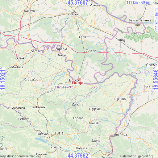
Gunja GPS coordinates[2]
44° 52' 48" North, 18° 51' 11.988" East
| Map corner | latitude | longitude |
|---|---|---|
| Upper-left | 45.37607°, | 18.15021° |
| Center: | 44.88°, | 18.85333° |
| Lower-right: | 44.37962°, | 19.55646° |
| Map W x H: | 110.8×110.8 km | = 68.8×68.8mi |
| max Lat: | 46.52694° ⇑76.6% North |
| Gunja: | 44.88° |
| min Lat: | ⇓23.4% South 42.54972° |
| min Long | Gunja | max Long |
| 13.52389° | 18.85333° | 19.37694° |
| W 96.8%⇐ | ⇒3.2% E |
Elevation
Elevation of Gunja is 84 m = 276 ft, and this is 69.3 m = 227 ft below average elevation for this country.
| Max E: |
827 m = 2713 ft | 81.6% |
| Avg. | 153.3 m = 503 ft | |
| Gunja | 84 m = 276 ft | |
Min E: |
-1 m = -3 ft | 18.4% |
See also: Croatia elevation on elevation.city.
Geographical zone
Gunja is located in North temperate zone (between Tropic of Cancer and the Arctic Circle). Distance of this Northern Tropic circle is 2384.3 km =1481.5 mi to South.| Distance of | km | miles | from Gunja |
|---|---|---|---|
| North Pole | 5016.9 | 3117.4 | to North |
| Arctic Circle | 2411 | 1498.1 | to North |
| Tropic Cancer | 2384.3 | 1481.5 | to South |
| Equator | 4990.2 | 3100.8 | to South |


Nearby cities:
15 places around Gunja: (largest is in red/bold)
• Bošnjaci
20.4 km =12.7 mi,  337°
337°
• Cerna
36 km =22.4 mi, 339°
• Drenovci
6.5 km =4 mi,  45°
45°
• Gradište
32 km =19.9 mi, 338°
• Komletinci
30.9 km =19.2 mi,  14°
14°
• Nijemci
32.3 km =20.1 mi,  26°
26°
• Otok
29.7 km =18.5 mi,  4°
4°
• Privlaka
35 km =21.7 mi,  357°
357°
• Rajevo Selo
7.7 km =4.8 mi,  309°
309°
• Račinovci
8.2 km =5.1 mi,  102°
102°
• Slavonski Šamac
35.4 km =22 mi, 305°
• Soljani
12.1 km =7.5 mi, 49°
• Vrbanja
12.7 km =7.9 mi, 27°
• Štitar
29.2 km =18.1 mi,  325°
325°
• Županja
25.1 km =15.6 mi, 330°
Sources, notices
• [Note1] Compared only with cities in Croatia existing in our database
• [Src1] Map data: © OpenStreetMap contributors (CC-BY-SA)
• [Src2] Other city data from geonames.org with taken over terms of usage.
• [Src3] Geographical zone / Annual Mean Temperature by Robert A. Rohde @ Wikipedia
