Verrettes geodata
Verrettes (Artibonite) is a populated place; located in Haiti in America/Port-au-Prince (GMT-4) time zone. With population of 48,724 people, there are 17 cities with bigger population in this country. Compared to other cities in Haiti, 51.9% of cities are located further ↓South; 52.8% of cities are located further ←West and 64.2% of cities have lower elevation than Verrettes. Note1


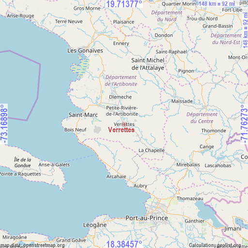
Verrettes GPS coordinates[2]
19° 3' 1.8" North, 72° 27' 57.06" West
| Map corner | latitude | longitude |
|---|---|---|
| Upper-left | 19.71377°, | -73.16898° |
| Center: | 19.0505°, | -72.46585° |
| Lower-right: | 18.38457°, | -71.76273° |
| Map W x H: | 147.8×147.8 km | = 91.8×91.8mi |
| max Lat: | 19.93984° ⇑48.1% North |
| Verrettes: | 19.0505° |
| min Lat: | ⇓51.9% South 18.05° |
| min Long | Verrettes | max Long |
| -74.4528° | -72.46585° | -71.72475° |
| W 52.8%⇐ | ⇒47.2% E |
Elevation
Elevation of Verrettes is 72 m = 236 ft, and this is 73.1 m = 240 ft below average elevation for this country.
| Max E: |
1466 m = 4810 ft | 35.8% |
| Avg. | 145.1 m = 476 ft | |
| Verrettes | 72 m = 236 ft | |
Min E: |
3 m = 10 ft | 64.2% |
See also: Verrettes elevation on elevation.city.
Geographical zone
Verrettes is located in North Torrid zone (between Equator and Tropic of Cancer). Distance of this Northern Tropic circle is 487.7 km =303 mi to North.| Distance of | km | miles | from Verrettes |
|---|---|---|---|
| North Pole | 7888.8 | 4901.9 | to North |
| Arctic Circle | 5283 | 3282.7 | to North |
| Tropic Cancer | 487.7 | 303 | to North |
| Equator | 2118.2 | 1316.2 | to South |


Nearby cities:
15 places around Verrettes: (largest is in red/bold)
• Anse à Galets
48.5 km =30.1 mi,  240°
240°
• Cabaret
35.3 km =21.9 mi,  172°
172°
• Dessalines
24.1 km =15 mi,  347°
347°
• Désarmes
10.1 km =6.3 mi,  128°
128°
• Ennery
48.2 km =30 mi,  357°
357°
• Gonaïves
50 km =31.1 mi,  332°
332°
• Grande Saline
39.8 km =24.7 mi,  306°
306°
• Hinche
48.5 km =30.1 mi,  76°
76°
• Marmelade
53.1 km =33 mi,  11°
11°
• Mayisad
37 km =23 mi,  67°
67°
• Mirebalais
44.9 km =27.9 mi,  122°
122°
• Pignon
48.5 km =30.1 mi,  49°
49°
• Saint-Marc
24.8 km =15.4 mi,  284°
284°
• Saint-Raphaël
51.5 km =32 mi,  32°
32°
• Thomonde
53.1 km =33 mi,  93°
93°
Sources, notices
• [Note1] Compared only with cities in Haiti existing in our database
• [Src1] Map data: © OpenStreetMap contributors (CC-BY-SA)
• [Src2] Other city data from geonames.org with taken over terms of usage.
• [Src3] Geographical zone / Annual Mean Temperature by Robert A. Rohde @ Wikipedia
