Hinche geodata
Hinche (Centre) is a seat of a first-order administrative division; located in Haiti in America/Port-au-Prince (GMT-4) time zone. With population of 18,590 people, there are 23 cities with bigger population in this country. Compared to other cities in Haiti, 54.7% of cities are located further ↓South; 83% of cities are located further ←West and 78.3% of cities have lower elevation than Hinche. Note1


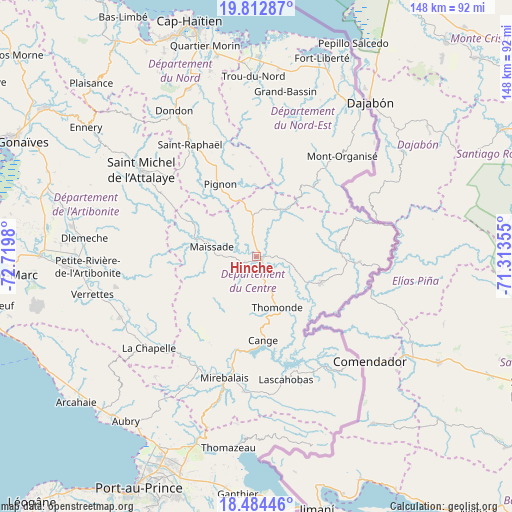
Hinche GPS coordinates[2]
19° 9' 0" North, 72° 1' 0.012" West
| Map corner | latitude | longitude |
|---|---|---|
| Upper-left | 19.81287°, | -72.7198° |
| Center: | 19.15°, | -72.01667° |
| Lower-right: | 18.48446°, | -71.31355° |
| Map W x H: | 147.7×147.7 km | = 91.8×91.8mi |
| max Lat: | 19.93984° ⇑45.3% North |
| Hinche: | 19.15° |
| min Lat: | ⇓54.7% South 18.05° |
| min Long | Hinche | max Long |
| -74.4528° | -72.01667° | -71.72475° |
| W 83%⇐ | ⇒17% E |
Elevation
Elevation of Hinche is 237 m = 778 ft, and this is 91.9 m = 302 ft above average elevation for this country.
| Max E: |
1466 m = 4810 ft | 21.7% |
| Hinche | 237 m 778 ft | |
| Avg. | 145.1 m = 476 ft | |
Min E: |
3 m = 10 ft | 78.3% |
See also: Haiti elevation on elevation.city.
Geographical zone
Hinche is located in North Torrid zone (between Equator and Tropic of Cancer). Distance of this Northern Tropic circle is 476.6 km =296.1 mi to North.| Distance of | km | miles | from Hinche |
|---|---|---|---|
| North Pole | 7877.8 | 4895 | to North |
| Arctic Circle | 5271.9 | 3275.8 | to North |
| Tropic Cancer | 476.6 | 296.1 | to North |
| Equator | 2129.3 | 1323.1 | to South |


Nearby cities:
15 places around Hinche: (largest is in red/bold)
• Acul Samedi
43.4 km =27 mi,  18°
18°
• Bahon
37 km =23 mi,  343°
343°
• Carice
32 km =19.9 mi,  37°
37°
• Cerca la Source
23.9 km =14.9 mi,  85°
85°
• Désarmes
43 km =26.7 mi,  246°
246°
• Lascahobas
36.5 km =22.7 mi,  166°
166°
• Mayisad
13.2 km =8.2 mi,  282°
282°
• Mirebalais
36.3 km =22.6 mi,  194°
194°
• Montòrganize
37.9 km =23.5 mi, 40°
• Perches
42.5 km =26.4 mi,  13°
13°
• Pignon
23.2 km =14.4 mi,  333°
333°
• Ranquitte
30 km =18.6 mi,  347°
347°
• Saint-Raphaël
37.4 km =23.2 mi, 329°
• Thomassique
20.2 km =12.6 mi,  111°
111°
• Thomonde
15.8 km =9.8 mi,  158°
158°
Sources, notices
• [Note1] Compared only with cities in Haiti existing in our database
• [Src1] Map data: © OpenStreetMap contributors (CC-BY-SA)
• [Src2] Other city data from geonames.org with taken over terms of usage.
• [Src3] Geographical zone / Annual Mean Temperature by Robert A. Rohde @ Wikipedia
