Gonaïves geodata
Gonaïves (Artibonite) is a seat of a first-order administrative division; located in Haiti in America/Port-au-Prince (GMT-4) time zone. With population of 84,961 people, there are 13 cities with bigger population in this country. Compared to other cities in Haiti, 64.2% of cities are located further ↓South; 56.6% of cities are located further →East and 99.1% of cities have higher elevation than Gonaïves. Note1


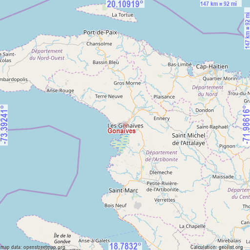
Gonaïves GPS coordinates[2]
19° 26' 51.18" North, 72° 41' 21.408" West
| Map corner | latitude | longitude |
|---|---|---|
| Upper-left | 20.10919°, | -73.39241° |
| Center: | 19.44755°, | -72.68928° |
| Lower-right: | 18.7832°, | -71.98616° |
| Map W x H: | 147.4×147.4 km | = 91.6×91.6mi |
| max Lat: | 19.93984° ⇑35.8% North |
| Gonaïves: | 19.44755° |
| min Lat: | ⇓64.2% South 18.05° |
| min Long | Gonaïves | max Long |
| -74.4528° | -72.68928° | -71.72475° |
| W 43.4%⇐ | ⇒56.6% E |
Elevation
Elevation of Gonaïves is 5 m = 16 ft, and this is 140.1 m = 460 ft below average elevation for this country.
| Max E: |
1466 m = 4810 ft | 99.1% |
| Avg. | 145.1 m = 476 ft | |
| Gonaïves | 5 m = 16 ft | |
Min E: |
3 m = 10 ft | 0.9% |
See also: Gonaïves elevation on elevation.city.
Geographical zone
Gonaïves is located in North Torrid zone (between Equator and Tropic of Cancer). Distance of this Northern Tropic circle is 443.6 km =275.6 mi to North.| Distance of | km | miles | from Gonaïves |
|---|---|---|---|
| North Pole | 7844.7 | 4874.5 | to North |
| Arctic Circle | 5238.8 | 3255.2 | to North |
| Tropic Cancer | 443.6 | 275.6 | to North |
| Equator | 2162.4 | 1343.7 | to South |


Nearby cities:
15 places around Gonaïves: (largest is in red/bold)
• Acul du Nord
46.6 km =29 mi,  56°
56°
• Anse Rouge
43.6 km =27.1 mi,  298°
298°
• Borgne
47.5 km =29.5 mi,  21°
21°
• Dessalines
27.5 km =17.1 mi,  138°
138°
• Ennery
21.7 km =13.5 mi,  79°
79°
• Fond Bassin Bleu
40.3 km =25 mi,  343°
343°
• Grande Saline
21.9 km =13.6 mi,  202°
202°
• Gros Morne
24.9 km =15.5 mi,  2°
2°
• Lenbe
41.5 km =25.8 mi,  46°
46°
• Marmelade
35.2 km =21.9 mi, 77°
• Pilate
28.4 km =17.6 mi,  30°
30°
• Plaisance
28.4 km =17.6 mi, 53°
• Port-Margot
43.4 km =27 mi,  38°
38°
• Saint-Marc
37.7 km =23.4 mi,  180°
180°
• Terre Neuve
19.4 km =12.1 mi,  330°
330°
Sources, notices
• [Note1] Compared only with cities in Haiti existing in our database
• [Src1] Map data: © OpenStreetMap contributors (CC-BY-SA)
• [Src2] Other city data from geonames.org with taken over terms of usage.
• [Src3] Geographical zone / Annual Mean Temperature by Robert A. Rohde @ Wikipedia
