Anse à Galets geodata
Anse à Galets (Ouest) is a populated place; located in Haiti in America/Port-au-Prince (GMT-4) time zone. With population of 7,178 people, there are 37 cities with bigger population in this country. Compared to other cities in Haiti, 51.9% of cities are located further ↑North; 66% of cities are located further →East and 57.5% of cities have higher elevation than Anse à Galets. Note1


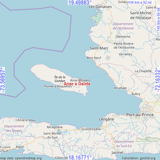
Anse à Galets GPS coordinates[2]
18° 50' 4.164" North, 72° 51' 59.184" West
| Map corner | latitude | longitude |
|---|---|---|
| Upper-left | 19.49863°, | -73.56957° |
| Center: | 18.83449°, | -72.86644° |
| Lower-right: | 18.16771°, | -72.16332° |
| Map W x H: | 148×148 km | = 92×92mi |
| max Lat: | 19.93984° ⇑51.9% North |
| Anse à Galets: | 18.83449° |
| min Lat: | ⇓48.1% South 18.05° |
| min Long | Anse à Galets | max Long |
| -74.4528° | -72.86644° | -71.72475° |
| W 34%⇐ | ⇒66% E |
Elevation
Elevation of Anse à Galets is 22 m = 72 ft, and this is 123.1 m = 404 ft below average elevation for this country.
| Max E: |
1466 m = 4810 ft | 57.5% |
| Avg. | 145.1 m = 476 ft | |
| Anse à Galets | 22 m = 72 ft | |
Min E: |
3 m = 10 ft | 42.5% |
See also: Haiti elevation on elevation.city.
Geographical zone
Anse à Galets is located in North Torrid zone (between Equator and Tropic of Cancer). Distance of this Northern Tropic circle is 511.7 km =318 mi to North.| Distance of | km | miles | from Anse à Galets |
|---|---|---|---|
| North Pole | 7912.9 | 4916.8 | to North |
| Arctic Circle | 5307 | 3297.6 | to North |
| Tropic Cancer | 511.7 | 318 | to North |
| Equator | 2094.2 | 1301.3 | to South |


Nearby cities:
15 places around Anse à Galets: (largest is in red/bold)
• Anse-à-Veau
62.6 km =38.9 mi,  233°
233°
• Cabaret
48.3 km =30 mi,  103°
103°
• Carrefour
59 km =36.7 mi,  123°
123°
• Dessalines
60.1 km =37.3 mi,  37°
37°
• Désarmes
53.1 km =33 mi,  70°
70°
• Grande Saline
49 km =30.4 mi,  12°
12°
• Grangwav
46.6 km =29 mi,  167°
167°
• Gressier
48.4 km =30.1 mi,  132°
132°
• Léogâne
43.5 km =27 mi,  145°
145°
• Miragoâne
49.2 km =30.6 mi,  208°
208°
• Petite Rivière de Nippes
55.6 km =34.5 mi,  224°
224°
• Port-au-Prince
64.3 km =40 mi, 120°
• Saint-Marc
35.4 km =22 mi,  30°
30°
• Tigwav
44.8 km =27.8 mi,  179°
179°
• Verrettes
48.5 km =30.1 mi,  60°
60°
Sources, notices
• [Note1] Compared only with cities in Haiti existing in our database
• [Src1] Map data: © OpenStreetMap contributors (CC-BY-SA)
• [Src2] Other city data from geonames.org with taken over terms of usage.
• [Src3] Geographical zone / Annual Mean Temperature by Robert A. Rohde @ Wikipedia
