Terre Neuve geodata
Terre Neuve (Artibonite) is a populated place; located in Haiti in America/Port-au-Prince (GMT-4) time zone. With population of 911 people, there are 103 cities with bigger population in this country. Compared to other cities in Haiti, 73.6% of cities are located further ↓South; 61.3% of cities are located further →East and 92.5% of cities have lower elevation than Terre Neuve. Note1


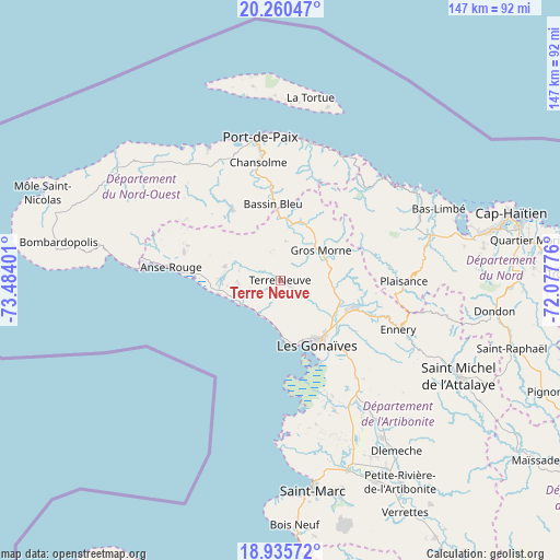
Terre Neuve GPS coordinates[2]
19° 35' 58.056" North, 72° 46' 51.168" West
| Map corner | latitude | longitude |
|---|---|---|
| Upper-left | 20.26047°, | -73.48401° |
| Center: | 19.59946°, | -72.78088° |
| Lower-right: | 18.93572°, | -72.07776° |
| Map W x H: | 147.3×147.3 km | = 91.5×91.5mi |
| max Lat: | 19.93984° ⇑26.4% North |
| Terre Neuve: | 19.59946° |
| min Lat: | ⇓73.6% South 18.05° |
| min Long | Terre Neuve | max Long |
| -74.4528° | -72.78088° | -71.72475° |
| W 38.7%⇐ | ⇒61.3% E |
Elevation
Elevation of Terre Neuve is 452 m = 1483 ft, and this is 306.9 m = 1007 ft above average elevation for this country.
| Max E: |
1466 m = 4810 ft | 7.5% |
| Terre Neuve | 452 m 1483 ft | |
| Avg. | 145.1 m = 476 ft | |
Min E: |
3 m = 10 ft | 92.5% |
See also: Haiti elevation on elevation.city.
Geographical zone
Terre Neuve is located in North Torrid zone (between Equator and Tropic of Cancer). Distance of this Northern Tropic circle is 426.7 km =265.1 mi to North.| Distance of | km | miles | from Terre Neuve |
|---|---|---|---|
| North Pole | 7827.8 | 4864 | to North |
| Arctic Circle | 5221.9 | 3244.7 | to North |
| Tropic Cancer | 426.7 | 265.1 | to North |
| Equator | 2179.3 | 1354.2 | to South |


Nearby cities:
15 places around Terre Neuve: (largest is in red/bold)
• Anse Rouge
29 km =18 mi,  277°
277°
• Arcahaie
28 km =17.4 mi,  329°
329°
• Borgne
38.4 km =23.9 mi,  44°
44°
• Ennery
33.5 km =20.8 mi,  112°
112°
• Fond Bassin Bleu
21.8 km =13.5 mi,  354°
354°
• Gonaïves
19.4 km =12.1 mi,  150°
150°
• Grande Saline
37.2 km =23.1 mi,  178°
178°
• Gros Morne
13.4 km =8.3 mi,  53°
53°
• Petite Anse
39.3 km =24.4 mi,  274°
274°
• Pilate
25.1 km =15.6 mi,  72°
72°
• Plaisance
32.6 km =20.3 mi,  90°
90°
• Port-Margot
40.4 km =25.1 mi, 65°
• Port-de-Paix
38.2 km =23.7 mi, 352°
• Saint-Louis du Nord
37.7 km =23.4 mi,  9°
9°
• Ti Port-de-Paix
37.5 km =23.3 mi, 351°
Sources, notices
• [Note1] Compared only with cities in Haiti existing in our database
• [Src1] Map data: © OpenStreetMap contributors (CC-BY-SA)
• [Src2] Other city data from geonames.org with taken over terms of usage.
• [Src3] Geographical zone / Annual Mean Temperature by Robert A. Rohde @ Wikipedia
