Borgne geodata
Borgne (Nord) is a populated place; located in Haiti in America/Port-au-Prince (GMT-4) time zone. With population of 4,288 people, there are 47 cities with bigger population in this country. Compared to other cities in Haiti, 96.2% of cities are located further ↓South; 50.9% of cities are located further →East and 85.8% of cities have higher elevation than Borgne. Note1


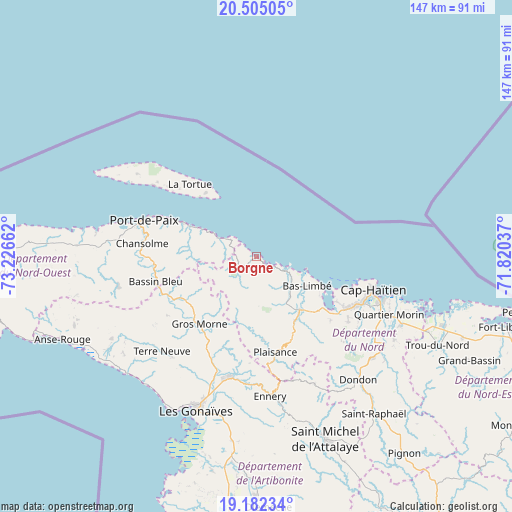
Borgne GPS coordinates[2]
19° 50' 42.252" North, 72° 31' 24.564" West
| Map corner | latitude | longitude |
|---|---|---|
| Upper-left | 20.50505°, | -73.22662° |
| Center: | 19.84507°, | -72.52349° |
| Lower-right: | 19.18234°, | -71.82037° |
| Map W x H: | 147.1×147.1 km | = 91.4×91.4mi |
| max Lat: | 19.93984° ⇑3.8% North |
| Borgne: | 19.84507° |
| min Lat: | ⇓96.2% South 18.05° |
| min Long | Borgne | max Long |
| -74.4528° | -72.52349° | -71.72475° |
| W 49.1%⇐ | ⇒50.9% E |
Elevation
Elevation of Borgne is 10 m = 33 ft, and this is 135.1 m = 443 ft below average elevation for this country.
| Max E: |
1466 m = 4810 ft | 85.8% |
| Avg. | 145.1 m = 476 ft | |
| Borgne | 10 m = 33 ft | |
Min E: |
3 m = 10 ft | 14.2% |
See also: Haiti elevation on elevation.city.
Geographical zone
Borgne is located in North Torrid zone (between Equator and Tropic of Cancer). Distance of this Northern Tropic circle is 399.4 km =248.2 mi to North.| Distance of | km | miles | from Borgne |
|---|---|---|---|
| North Pole | 7800.5 | 4847 | to North |
| Arctic Circle | 5194.6 | 3227.8 | to North |
| Tropic Cancer | 399.4 | 248.2 | to North |
| Equator | 2206.6 | 1371.1 | to South |


Nearby cities:
15 places around Borgne: (largest is in red/bold)
• Acul du Nord
28.1 km =17.5 mi,  130°
130°
• Ennery
40.4 km =25.1 mi,  174°
174°
• Fond Bassin Bleu
29.4 km =18.3 mi,  258°
258°
• Gros Morne
25.2 km =15.7 mi,  219°
219°
• Lenbe
19.9 km =12.4 mi,  140°
140°
• Marmelade
40.2 km =25 mi,  155°
155°
• Okap
35.3 km =21.9 mi,  105°
105°
• Pilate
20 km =12.4 mi,  188°
188°
• Plaine du Nord
32.5 km =20.2 mi, 125°
• Plaisance
28 km =17.4 mi, 168°
• Port-Margot
14.3 km =8.9 mi, 136°
• Port-de-Paix
33.8 km =21 mi,  288°
288°
• Saint-Louis du Nord
22.9 km =14.2 mi,  295°
295°
• Terre Neuve
38.4 km =23.9 mi, 224°
• Ti Port-de-Paix
33.8 km =21 mi, 286°
Sources, notices
• [Note1] Compared only with cities in Haiti existing in our database
• [Src1] Map data: © OpenStreetMap contributors (CC-BY-SA)
• [Src2] Other city data from geonames.org with taken over terms of usage.
• [Src3] Geographical zone / Annual Mean Temperature by Robert A. Rohde @ Wikipedia
