Port-Margot geodata
Port-Margot (Nord) is a populated place; located in Haiti in America/Port-au-Prince (GMT-4) time zone. With population of 3,070 people, there are 59 cities with bigger population in this country. Compared to other cities in Haiti, 91.5% of cities are located further ↓South; 53.8% of cities are located further ←West and 50% of cities have lower elevation than Port-Margot. Note1


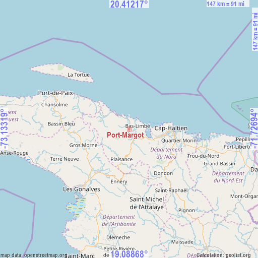
Port-Margot GPS coordinates[2]
19° 45' 6.48" North, 72° 25' 48.216" West
| Map corner | latitude | longitude |
|---|---|---|
| Upper-left | 20.41217°, | -73.13319° |
| Center: | 19.7518°, | -72.43006° |
| Lower-right: | 19.08868°, | -71.72694° |
| Map W x H: | 147.2×147.2 km | = 91.5×91.5mi |
| max Lat: | 19.93984° ⇑8.5% North |
| Port-Margot: | 19.7518° |
| min Lat: | ⇓91.5% South 18.05° |
| min Long | Port-Margot | max Long |
| -74.4528° | -72.43006° | -71.72475° |
| W 53.8%⇐ | ⇒46.2% E |
Elevation
Elevation of Port-Margot is 37 m = 121 ft, and this is 108.1 m = 355 ft below average elevation for this country.
| Max E: |
1466 m = 4810 ft | 50% |
| Avg. | 145.1 m = 476 ft | |
| Port-Margot | 37 m = 121 ft | |
Min E: |
3 m = 10 ft | 50% |
See also: Haiti elevation on elevation.city.
Geographical zone
Port-Margot is located in North Torrid zone (between Equator and Tropic of Cancer). Distance of this Northern Tropic circle is 409.7 km =254.6 mi to North.| Distance of | km | miles | from Port-Margot |
|---|---|---|---|
| North Pole | 7810.9 | 4853.5 | to North |
| Arctic Circle | 5205 | 3234.2 | to North |
| Tropic Cancer | 409.7 | 254.6 | to North |
| Equator | 2196.2 | 1364.7 | to South |


Nearby cities:
15 places around Port-Margot: (largest is in red/bold)
• Acul du Nord
14 km =8.7 mi,  124°
124°
• Borgne
14.3 km =8.9 mi,  316°
316°
• Dondon
31.7 km =19.7 mi,  141°
141°
• Ennery
30.4 km =18.9 mi,  190°
190°
• Grande Rivière du Nord
33.5 km =20.8 mi,  125°
125°
• Gros Morne
27.5 km =17.1 mi,  250°
250°
• Lenbe
5.8 km =3.6 mi,  151°
151°
• Limonade
33.3 km =20.7 mi,  105°
105°
• Marmelade
27 km =16.8 mi,  164°
164°
• Milot
27.7 km =17.2 mi, 125°
• Okap
24.3 km =15.1 mi,  88°
88°
• Pilate
15.9 km =9.9 mi,  233°
233°
• Plaine du Nord
18.7 km =11.6 mi, 116°
• Plaisance
17.6 km =10.9 mi, 193°
• Quartier Morin
29.2 km =18.1 mi,  102°
102°
Sources, notices
• [Note1] Compared only with cities in Haiti existing in our database
• [Src1] Map data: © OpenStreetMap contributors (CC-BY-SA)
• [Src2] Other city data from geonames.org with taken over terms of usage.
• [Src3] Geographical zone / Annual Mean Temperature by Robert A. Rohde @ Wikipedia
