Fond Bassin Bleu geodata
Fond Bassin Bleu (Nord-Ouest) is a populated place; located in Haiti in America/Port-au-Prince (GMT-4) time zone. With population of 1,184 people, there are 100 cities with bigger population in this country. Compared to other cities in Haiti, 93.4% of cities are located further ↓South; 62.3% of cities are located further →East and 73.6% of cities have lower elevation than Fond Bassin Bleu. Note1


Fond Bassin Bleu GPS coordinates[2]
19° 47' 40.02" North, 72° 47' 58.164" West
| Map corner | latitude | longitude |
|---|---|---|
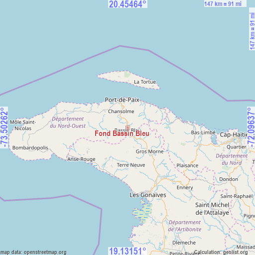
| Upper-left | 20.45464°, | -73.50262° |
| Center: | 19.79445°, | -72.79949° |
| Lower-right: | 19.13151°, | -72.09637° |
| Map W x H: | 147.1×147.1 km | = 91.4×91.4mi |
| max Lat: | 19.93984° ⇑6.6% North |
| Fond Bassin Bleu: | 19.79445° |
| min Lat: | ⇓93.4% South 18.05° |
| min Long | Fond Bassin Ble | max Long |
| -74.4528° | -72.79949° | -71.72475° |
| W 37.7%⇐ | ⇒62.3% E |
Elevation
Elevation of Fond Bassin Bleu is 142 m = 466 ft, and this is 3.1 m = 10 ft below average elevation for this country.
| Max E: |
1466 m = 4810 ft | 26.4% |
| Avg. | 145.1 m = 476 ft | |
| Fond Bassin Bleu | 142 m = 466 ft | |
Min E: |
3 m = 10 ft | 73.6% |
See also: Haiti elevation on elevation.city.
Geographical zone
Fond Bassin Bleu is located in North Torrid zone (between Equator and Tropic of Cancer). Distance of this Northern Tropic circle is 405 km =251.7 mi to North.| Distance of | km | miles | from Fond Bassin Bleu |
|---|---|---|---|
| North Pole | 7806.1 | 4850.5 | to North |
| Arctic Circle | 5200.2 | 3231.3 | to North |
| Tropic Cancer | 405 | 251.7 | to North |
| Equator | 2200.9 | 1367.6 | to South |


Nearby cities:
15 places around Fond Bassin Bleu: (largest is in red/bold)
• Anse Rouge
32.2 km =20 mi,  236°
236°
• Arcahaie
12.5 km =7.8 mi,  281°
281°
• Borgne
29.4 km =18.3 mi,  78°
78°
• Gonaïves
40.3 km =25 mi,  163°
163°
• Gros Morne
18.7 km =11.6 mi,  137°
137°
• Jean-Rabel
41.5 km =25.8 mi, 279°
• Lenbe
42.6 km =26.5 mi,  103°
103°
• Petite Anse
41.5 km =25.8 mi, 243°
• Pilate
29.5 km =18.3 mi,  118°
118°
• Plaisance
40.8 km =25.4 mi, 122°
• Port-Margot
38.9 km =24.2 mi, 96°
• Port-de-Paix
16.5 km =10.3 mi,  348°
348°
• Saint-Louis du Nord
17.5 km =10.9 mi,  27°
27°
• Terre Neuve
21.8 km =13.5 mi,  174°
174°
• Ti Port-de-Paix
15.8 km =9.8 mi, 347°
Sources, notices
• [Note1] Compared only with cities in Haiti existing in our database
• [Src1] Map data: © OpenStreetMap contributors (CC-BY-SA)
• [Src2] Other city data from geonames.org with taken over terms of usage.
• [Src3] Geographical zone / Annual Mean Temperature by Robert A. Rohde @ Wikipedia
