Okap geodata
Okap (Nord) is a seat of a first-order administrative division; located in Haiti in America/Port-au-Prince (GMT-4) time zone. With population of 134,815 people, there are 7 cities with bigger population in this country. Compared to other cities in Haiti, 92.5% of cities are located further ↓South; 70.8% of cities are located further ←West and 95.3% of cities have higher elevation than Okap. Note1


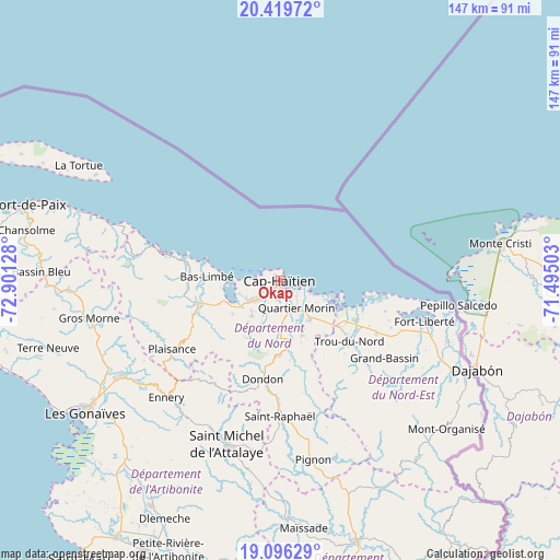
Okap GPS coordinates[2]
19° 45' 33.768" North, 72° 11' 53.34" West
| Map corner | latitude | longitude |
|---|---|---|
| Upper-left | 20.41972°, | -72.90128° |
| Center: | 19.75938°, | -72.19815° |
| Lower-right: | 19.09629°, | -71.49503° |
| Map W x H: | 147.2×147.2 km | = 91.5×91.5mi |
| max Lat: | 19.93984° ⇑7.5% North |
| Okap: | 19.75938° |
| min Lat: | ⇓92.5% South 18.05° |
| min Long | Okap | max Long |
| -74.4528° | -72.19815° | -71.72475° |
| W 70.8%⇐ | ⇒29.2% E |
Elevation
Elevation of Okap is 7 m = 23 ft, and this is 138.1 m = 453 ft below average elevation for this country.
| Max E: |
1466 m = 4810 ft | 95.3% |
| Avg. | 145.1 m = 476 ft | |
| Okap | 7 m = 23 ft | |
Min E: |
3 m = 10 ft | 4.7% |
See also: Okap elevation on elevation.city.
Geographical zone
Okap is located in North Torrid zone (between Equator and Tropic of Cancer). Distance of this Northern Tropic circle is 408.9 km =254.1 mi to North.| Distance of | km | miles | from Okap |
|---|---|---|---|
| North Pole | 7810 | 4852.9 | to North |
| Arctic Circle | 5204.1 | 3233.7 | to North |
| Tropic Cancer | 408.9 | 254.1 | to North |
| Equator | 2197 | 1365.2 | to South |


Nearby cities:
15 places around Okap: (largest is in red/bold)
• Acul du Nord
15.4 km =9.6 mi,  235°
235°
• Bahon
33.4 km =20.8 mi,  164°
164°
• Caracol
20.3 km =12.6 mi,  111°
111°
• Dondon
26.2 km =16.3 mi,  190°
190°
• Grande Rivière du Nord
20.5 km =12.7 mi,  171°
171°
• Lenbe
22.3 km =13.9 mi,  254°
254°
• Limonade
12.6 km =7.8 mi,  142°
142°
• Marmelade
31.9 km =19.8 mi,  212°
212°
• Milot
16.9 km =10.5 mi, 185°
• Phaëton
32.9 km =20.4 mi, 106°
• Plaine du Nord
11.8 km =7.3 mi,  219°
219°
• Plaisance
33.6 km =20.9 mi, 237°
• Port-Margot
24.3 km =15.1 mi,  268°
268°
• Quartier Morin
8.2 km =5.1 mi,  148°
148°
• Trou du Nord
24.1 km =15 mi,  131°
131°
In other languages:
- In Spanish: Cabo Haitiano
- In France: Cap-Haïtien
- In German: Cap-Haitien, Cap-Haïtien
- In Russian: Кап-Аитьене, Кап-Аитьен
- In Chinese: 海地角
Sources, notices
• [Note1] Compared only with cities in Haiti existing in our database
• [Src1] Map data: © OpenStreetMap contributors (CC-BY-SA)
• [Src2] Other city data from geonames.org with taken over terms of usage.
• [Src3] Geographical zone / Annual Mean Temperature by Robert A. Rohde @ Wikipedia
