Montòrganize geodata
Montòrganize (Nord-Est) is a populated place; located in Haiti in America/Port-au-Prince (GMT-4) time zone. With population of 2,104 people, there are 73 cities with bigger population in this country. Compared to other cities in Haiti, 61.3% of cities are located further ↓South; 97.2% of cities are located further ←West and 95.3% of cities have lower elevation than Montòrganize. Note1


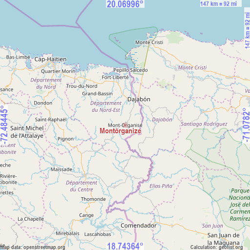
Montòrganize GPS coordinates[2]
19° 24' 29.34" North, 71° 46' 52.752" West
| Map corner | latitude | longitude |
|---|---|---|
| Upper-left | 20.06996°, | -72.48445° |
| Center: | 19.40815°, | -71.78132° |
| Lower-right: | 18.74364°, | -71.0782° |
| Map W x H: | 147.5×147.5 km | = 91.7×91.7mi |
| max Lat: | 19.93984° ⇑38.7% North |
| Montòrganize: | 19.40815° |
| min Lat: | ⇓61.3% South 18.05° |
| min Long | Montòrganize | max Long |
| -74.4528° | -71.78132° | -71.72475° |
| W 97.2%⇐ | ⇒2.8% E |
Elevation
Elevation of Montòrganize is 672 m = 2205 ft, and this is 526.9 m = 1729 ft above average elevation for this country.
| Max E: |
1466 m = 4810 ft | 4.7% |
| Montòrganize | 672 m 2205 ft | |
| Avg. | 145.1 m = 476 ft | |
Min E: |
3 m = 10 ft | 95.3% |
See also: Haiti elevation on elevation.city.
Geographical zone
Montòrganize is located in North Torrid zone (between Equator and Tropic of Cancer). Distance of this Northern Tropic circle is 447.9 km =278.3 mi to North.| Distance of | km | miles | from Montòrganize |
|---|---|---|---|
| North Pole | 7849.1 | 4877.2 | to North |
| Arctic Circle | 5243.2 | 3258 | to North |
| Tropic Cancer | 447.9 | 278.3 | to North |
| Equator | 2158 | 1340.9 | to South |


Nearby cities:
15 places around Montòrganize: (largest is in red/bold)
• Acul Samedi
16.2 km =10.1 mi,  319°
319°
• Bahon
35.6 km =22.1 mi,  281°
281°
• Carice
6.1 km =3.8 mi,  236°
236°
• Cerca la Source
26.8 km =16.7 mi,  181°
181°
• Dérac
27.6 km =17.1 mi,  352°
352°
• Ferrier
23.1 km =14.4 mi,  0°
0°
• Fort Liberté
28.9 km =18 mi, 348°
• Hinche
37.9 km =23.5 mi,  220°
220°
• Ouanaminthe
16.8 km =10.4 mi,  20°
20°
• Perches
19.5 km =12.1 mi,  310°
310°
• Phaëton
32.1 km =19.9 mi,  337°
337°
• Pignon
36.1 km =22.4 mi,  257°
257°
• Ranquitte
31.4 km =19.5 mi,  271°
271°
• Thomassique
36.7 km =22.8 mi,  189°
189°
• Trou du Nord
34.4 km =21.4 mi, 312°
Sources, notices
• [Note1] Compared only with cities in Haiti existing in our database
• [Src1] Map data: © OpenStreetMap contributors (CC-BY-SA)
• [Src2] Other city data from geonames.org with taken over terms of usage.
• [Src3] Geographical zone / Annual Mean Temperature by Robert A. Rohde @ Wikipedia
