Boldog geodata
Boldog (Heves) is a populated place; located in Hungary in Europe/Budapest (GMT+2) time zone. With population of 3,131 people, there are 472 cities with bigger population in this country. Compared to other cities in Hungary, 62.6% of cities are located further ↓South; 54.5% of cities are located further ←West and 56.5% of cities have higher elevation than Boldog. Note1


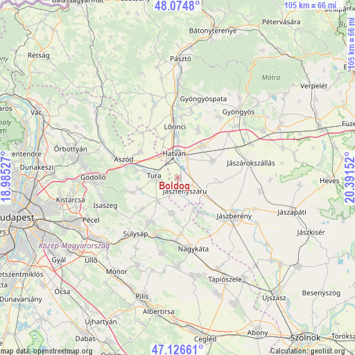
Boldog GPS coordinates[2]
47° 36' 10.26" North, 19° 41' 18.204" East
| Map corner | latitude | longitude |
|---|---|---|
| Upper-left | 48.0748°, | 18.98527° |
| Center: | 47.60285°, | 19.68839° |
| Lower-right: | 47.12661°, | 20.39152° |
| Map W x H: | 105.4×105.4 km | = 65.5×65.5mi |
| max Lat: | 48.46667° ⇑37.4% North |
| Boldog: | 47.60285° |
| min Lat: | ⇓62.6% South 45.79108° |
| min Long | Boldog | max Long |
| 16.27358° | 19.68839° | 22.68096° |
| W 54.5%⇐ | ⇒45.5% E |
Elevation
Elevation of Boldog is 112 m = 367 ft, and this is 17.7 m = 58 ft below average elevation for this country.
| Max E: |
444 m = 1457 ft | 56.5% |
| Avg. | 129.7 m = 426 ft | |
| Boldog | 112 m = 367 ft | |
Min E: |
71 m = 233 ft | 43.5% |
See also: Hungary elevation on elevation.city.
Geographical zone
Boldog is located in North temperate zone (between Tropic of Cancer and the Arctic Circle). Distance of this North polar circle is 2108.2 km =1310 mi to North.| Distance of | km | miles | from Boldog |
|---|---|---|---|
| North Pole | 4714.1 | 2929.2 | to North |
| Arctic Circle | 2108.2 | 1310 | to North |
| Tropic Cancer | 2687 | 1669.6 | to South |
| Equator | 5292.9 | 3288.9 | to South |


Nearby cities:
15 places around Boldog: (largest is in red/bold)
• Csány
11.7 km =7.3 mi,  64°
64°
• Dány
14.2 km =8.8 mi,  229°
229°
• Galgahévíz
9.3 km =5.8 mi,  279°
279°
• Hatvan
7.1 km =4.4 mi,  356°
356°
• Heréd
12.2 km =7.6 mi,  340°
340°
• Hort
12.4 km =7.7 mi,  37°
37°
• Hévízgyörk
13.3 km =8.3 mi, 284°
• Kartal
13.4 km =8.3 mi,  304°
304°
• Lőrinci
14.5 km =9 mi, 357°
• Szentlőrinckáta
10.5 km =6.5 mi,  152°
152°
• Tura
6.5 km =4 mi, 276°
• Tóalmás
10.7 km =6.6 mi,  188°
188°
• Valkó
13.9 km =8.6 mi,  251°
251°
• Vácszentlászló
11.7 km =7.3 mi, 254°
• Zsámbok
8.8 km =5.5 mi,  221°
221°
Sources, notices
• [Note1] Compared only with cities in Hungary existing in our database
• [Src1] Map data: © OpenStreetMap contributors (CC-BY-SA)
• [Src2] Other city data from geonames.org with taken over terms of usage.
• [Src3] Geographical zone / Annual Mean Temperature by Robert A. Rohde @ Wikipedia
