Galgahévíz geodata
Galgahévíz (Pest) is a populated place; located in Hungary in Europe/Budapest (GMT+2) time zone. With population of 2,641 people, there are 583 cities with bigger population in this country. Compared to other cities in Hungary, 64.1% of cities are located further ↓South; 51.8% of cities are located further ←West and 60.4% of cities have lower elevation than Galgahévíz. Note1


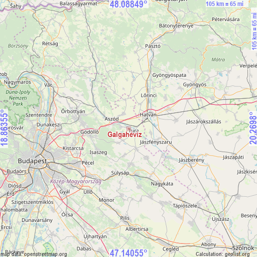
Galgahévíz GPS coordinates[2]
47° 37' 0.012" North, 19° 34' 0.012" East
| Map corner | latitude | longitude |
|---|---|---|
| Upper-left | 48.08849°, | 18.86355° |
| Center: | 47.61667°, | 19.56667° |
| Lower-right: | 47.14055°, | 20.2698° |
| Map W x H: | 105.4×105.4 km | = 65.5×65.5mi |
| max Lat: | 48.46667° ⇑35.9% North |
| Galgahévíz: | 47.61667° |
| min Lat: | ⇓64.1% South 45.79108° |
| min Long | Galgahévíz | max Long |
| 16.27358° | 19.56667° | 22.68096° |
| W 51.8%⇐ | ⇒48.2% E |
Elevation
Elevation of Galgahévíz is 126 m = 413 ft, and this is 3.7 m = 12 ft below average elevation for this country.
| Max E: |
444 m = 1457 ft | 39.6% |
| Avg. | 129.7 m = 426 ft | |
| Galgahévíz | 126 m = 413 ft | |
Min E: |
71 m = 233 ft | 60.4% |
See also: Hungary elevation on elevation.city.
Geographical zone
Galgahévíz is located in North temperate zone (between Tropic of Cancer and the Arctic Circle). Distance of this North polar circle is 2106.7 km =1309 mi to North.| Distance of | km | miles | from Galgahévíz |
|---|---|---|---|
| North Pole | 4712.6 | 2928.3 | to North |
| Arctic Circle | 2106.7 | 1309 | to North |
| Tropic Cancer | 2688.6 | 1670.6 | to South |
| Equator | 5294.5 | 3289.8 | to South |


Nearby cities:
15 places around Galgahévíz: (largest is in red/bold)
• Aszód
7.7 km =4.8 mi,  300°
300°
• Bag
6.5 km =4 mi,  286°
286°
• Boldog
9.3 km =5.8 mi,  99°
99°
• Domony
11 km =6.8 mi, 293°
• Dány
10.9 km =6.8 mi,  188°
188°
• Hatvan
10.4 km =6.5 mi,  57°
57°
• Heréd
11.1 km =6.9 mi,  26°
26°
• Hévízgyörk
4.2 km =2.6 mi, 296°
• Iklad
11.2 km =7 mi, 298°
• Kartal
6.4 km =4 mi,  343°
343°
• Tura
2.8 km =1.7 mi,  106°
106°
• Tóalmás
14.2 km =8.8 mi,  148°
148°
• Valkó
7.1 km =4.4 mi,  214°
214°
• Vácszentlászló
5.2 km =3.2 mi,  204°
204°
• Zsámbok
8.7 km =5.4 mi,  157°
157°
Sources, notices
• [Note1] Compared only with cities in Hungary existing in our database
• [Src1] Map data: © OpenStreetMap contributors (CC-BY-SA)
• [Src2] Other city data from geonames.org with taken over terms of usage.
• [Src3] Geographical zone / Annual Mean Temperature by Robert A. Rohde @ Wikipedia
