Tát geodata
Tát (Komárom-Esztergom) is a populated place; located in Hungary in Europe/Budapest (GMT+2) time zone. With population of 5,575 people, there are 272 cities with bigger population in this country. Compared to other cities in Hungary, 73.9% of cities are located further ↓South; 74.5% of cities are located further →East and 65.5% of cities have higher elevation than Tát. Note1


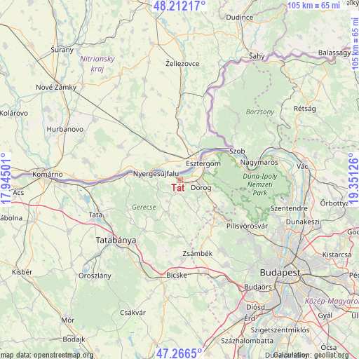
Tát GPS coordinates[2]
47° 44' 29.328" North, 18° 38' 53.268" East
| Map corner | latitude | longitude |
|---|---|---|
| Upper-left | 48.21217°, | 17.94501° |
| Center: | 47.74148°, | 18.64813° |
| Lower-right: | 47.2665°, | 19.35126° |
| Map W x H: | 105.1×105.1 km | = 65.3×65.3mi |
| max Lat: | 48.46667° ⇑26.1% North |
| Tát: | 47.74148° |
| min Lat: | ⇓73.9% South 45.79108° |
| min Long | Tát | max Long |
| 16.27358° | 18.64813° | 22.68096° |
| W 25.5%⇐ | ⇒74.5% E |
Elevation
Elevation of Tát is 106 m = 348 ft, and this is 23.7 m = 78 ft below average elevation for this country.
| Max E: |
444 m = 1457 ft | 65.5% |
| Avg. | 129.7 m = 426 ft | |
| Tát | 106 m = 348 ft | |
Min E: |
71 m = 233 ft | 34.5% |
See also: Hungary elevation on elevation.city.
Geographical zone
Tát is located in North temperate zone (between Tropic of Cancer and the Arctic Circle). Distance of this North polar circle is 2092.8 km =1300.4 mi to North.| Distance of | km | miles | from Tát |
|---|---|---|---|
| North Pole | 4698.7 | 2919.6 | to North |
| Arctic Circle | 2092.8 | 1300.4 | to North |
| Tropic Cancer | 2702.4 | 1679.2 | to South |
| Equator | 5308.4 | 3298.5 | to South |


Nearby cities:
15 places around Tát: (largest is in red/bold)
• Bajna
10.4 km =6.5 mi,  201°
201°
• Csolnok
7.6 km =4.7 mi,  137°
137°
• Dorog
7 km =4.3 mi,  109°
109°
• Esztergom
9 km =5.6 mi,  50°
50°
• Kesztölc
11.9 km =7.4 mi, 105°
• Lábatlan
11.4 km =7.1 mi,  273°
273°
• Nyergesújfalu
7.1 km =4.4 mi,  287°
287°
• Piliscsaba
18 km =11.2 mi,  131°
131°
• Piliscsév
14.5 km =9 mi,  118°
118°
• Pilismarót
17.7 km =11 mi,  74°
74°
• Sárisáp
7.5 km =4.7 mi,  161°
161°
• Süttő
15 km =9.3 mi,  277°
277°
• Tardos
17.6 km =10.9 mi,  239°
239°
• Tarján
17.8 km =11.1 mi,  215°
215°
• Tokod
2.2 km =1.4 mi, 158°
Sources, notices
• [Note1] Compared only with cities in Hungary existing in our database
• [Src1] Map data: © OpenStreetMap contributors (CC-BY-SA)
• [Src2] Other city data from geonames.org with taken over terms of usage.
• [Src3] Geographical zone / Annual Mean Temperature by Robert A. Rohde @ Wikipedia
