Tokod geodata
Tokod (Komárom-Esztergom) is a populated place; located in Hungary in Europe/Budapest (GMT+2) time zone. With population of 4,271 people, there are 349 cities with bigger population in this country. Compared to other cities in Hungary, 72.1% of cities are located further ↓South; 73.9% of cities are located further →East and 54.3% of cities have lower elevation than Tokod. Note1


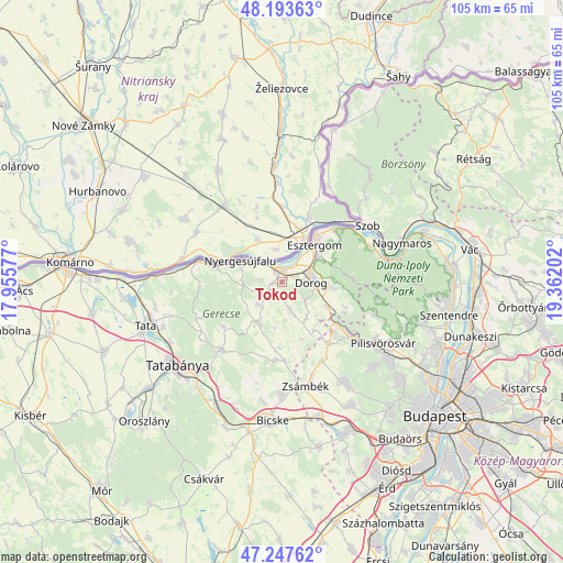
Tokod GPS coordinates[2]
47° 43' 21.972" North, 18° 39' 32.004" East
| Map corner | latitude | longitude |
|---|---|---|
| Upper-left | 48.19363°, | 17.95577° |
| Center: | 47.72277°, | 18.65889° |
| Lower-right: | 47.24762°, | 19.36202° |
| Map W x H: | 105.2×105.2 km | = 65.4×65.4mi |
| max Lat: | 48.46667° ⇑27.9% North |
| Tokod: | 47.72277° |
| min Lat: | ⇓72.1% South 45.79108° |
| min Long | Tokod | max Long |
| 16.27358° | 18.65889° | 22.68096° |
| W 26.1%⇐ | ⇒73.9% E |
Elevation
Elevation of Tokod is 120 m = 394 ft, and this is 9.7 m = 32 ft below average elevation for this country.
| Max E: |
444 m = 1457 ft | 45.7% |
| Avg. | 129.7 m = 426 ft | |
| Tokod | 120 m = 394 ft | |
Min E: |
71 m = 233 ft | 54.3% |
See also: Hungary elevation on elevation.city.
Geographical zone
Tokod is located in North temperate zone (between Tropic of Cancer and the Arctic Circle). Distance of this North polar circle is 2094.9 km =1301.7 mi to North.| Distance of | km | miles | from Tokod |
|---|---|---|---|
| North Pole | 4700.8 | 2920.9 | to North |
| Arctic Circle | 2094.9 | 1301.7 | to North |
| Tropic Cancer | 2700.4 | 1678 | to South |
| Equator | 5306.3 | 3297.2 | to South |


Nearby cities:
15 places around Tokod: (largest is in red/bold)
• Bajna
8.9 km =5.5 mi,  211°
211°
• Csolnok
5.5 km =3.4 mi,  129°
129°
• Dorog
5.8 km =3.6 mi,  91°
91°
• Esztergom
9.9 km =6.2 mi,  38°
38°
• Kesztölc
10.7 km =6.6 mi,  96°
96°
• Lábatlan
12.5 km =7.8 mi,  282°
282°
• Nyergesújfalu
8.7 km =5.4 mi,  298°
298°
• Perbál
16.7 km =10.4 mi,  152°
152°
• Piliscsaba
16.1 km =10 mi, 127°
• Piliscsév
12.9 km =8 mi,  112°
112°
• Sárisáp
5.3 km =3.3 mi,  163°
163°
• Süttő
16.2 km =10.1 mi, 284°
• Tardos
17.4 km =10.8 mi,  247°
247°
• Tarján
16.7 km =10.4 mi,  221°
221°
• Tát
2.2 km =1.4 mi,  338°
338°
Sources, notices
• [Note1] Compared only with cities in Hungary existing in our database
• [Src1] Map data: © OpenStreetMap contributors (CC-BY-SA)
• [Src2] Other city data from geonames.org with taken over terms of usage.
• [Src3] Geographical zone / Annual Mean Temperature by Robert A. Rohde @ Wikipedia
