Csolnok geodata
Csolnok (Komárom-Esztergom) is a populated place; located in Hungary in Europe/Budapest (GMT+2) time zone. With population of 3,381 people, there are 431 cities with bigger population in this country. Compared to other cities in Hungary, 70% of cities are located further ↓South; 72.9% of cities are located further →East and 93.3% of cities have lower elevation than Csolnok. Note1


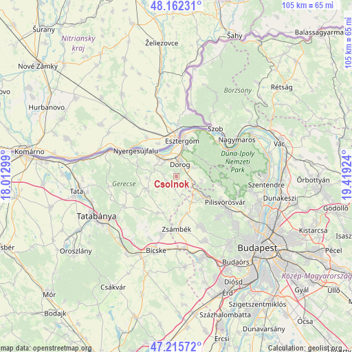
Csolnok GPS coordinates[2]
47° 41' 28.176" North, 18° 42' 57.996" East
| Map corner | latitude | longitude |
|---|---|---|
| Upper-left | 48.16231°, | 18.01299° |
| Center: | 47.69116°, | 18.71611° |
| Lower-right: | 47.21572°, | 19.41924° |
| Map W x H: | 105.3×105.2 km | = 65.4×65.4mi |
| max Lat: | 48.46667° ⇑30% North |
| Csolnok: | 47.69116° |
| min Lat: | ⇓70% South 45.79108° |
| min Long | Csolnok | max Long |
| 16.27358° | 18.71611° | 22.68096° |
| W 27.1%⇐ | ⇒72.9% E |
Elevation
Elevation of Csolnok is 209 m = 686 ft, and this is 79.3 m = 260 ft above average elevation for this country.
| Max E: |
444 m = 1457 ft | 6.7% |
| Csolnok | 209 m 686 ft | |
| Avg. | 129.7 m = 426 ft | |
Min E: |
71 m = 233 ft | 93.3% |
See also: Hungary elevation on elevation.city.
Geographical zone
Csolnok is located in North temperate zone (between Tropic of Cancer and the Arctic Circle). Distance of this North polar circle is 2098.4 km =1303.9 mi to North.| Distance of | km | miles | from Csolnok |
|---|---|---|---|
| North Pole | 4704.3 | 2923.1 | to North |
| Arctic Circle | 2098.4 | 1303.9 | to North |
| Tropic Cancer | 2696.8 | 1675.7 | to South |
| Equator | 5302.8 | 3295 | to South |


Nearby cities:
15 places around Csolnok: (largest is in red/bold)
• Bajna
9.8 km =6.1 mi,  245°
245°
• Dorog
3.6 km =2.2 mi,  24°
24°
• Esztergom
11.5 km =7.1 mi,  9°
9°
• Kesztölc
6.8 km =4.2 mi,  69°
69°
• Nyergesújfalu
14.2 km =8.8 mi,  302°
302°
• Perbál
11.8 km =7.3 mi,  163°
163°
• Piliscsaba
10.6 km =6.6 mi,  126°
126°
• Piliscsév
7.8 km =4.8 mi,  99°
99°
• Pilismarót
15.8 km =9.8 mi,  48°
48°
• Pilisszentkereszt
14.1 km =8.8 mi,  89°
89°
• Pilisszántó
13.1 km =8.1 mi, 100°
• Sárisáp
3.2 km =2 mi,  240°
240°
• Tokod
5.5 km =3.4 mi,  309°
309°
• Tát
7.6 km =4.7 mi,  317°
317°
• Zsámbék
15.9 km =9.9 mi,  178°
178°
Sources, notices
• [Note1] Compared only with cities in Hungary existing in our database
• [Src1] Map data: © OpenStreetMap contributors (CC-BY-SA)
• [Src2] Other city data from geonames.org with taken over terms of usage.
• [Src3] Geographical zone / Annual Mean Temperature by Robert A. Rohde @ Wikipedia
