Lábatlan geodata
Lábatlan (Komárom-Esztergom) is a populated place; located in Hungary in Europe/Budapest (GMT+2) time zone. With population of 5,357 people, there are 284 cities with bigger population in this country. Compared to other cities in Hungary, 74.3% of cities are located further ↓South; 76.7% of cities are located further →East and 73.2% of cities have lower elevation than Lábatlan. Note1


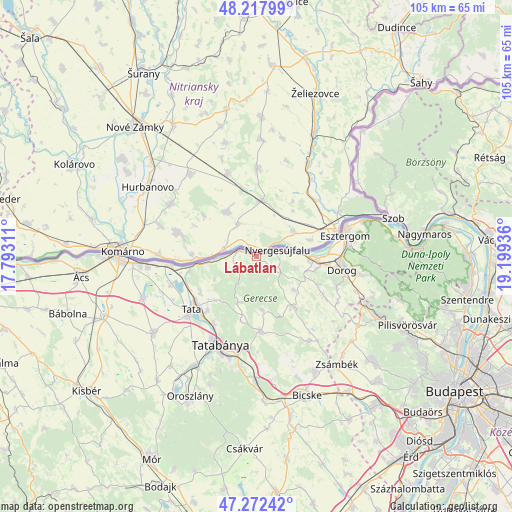
Lábatlan GPS coordinates[2]
47° 44' 50.46" North, 18° 29' 46.428" East
| Map corner | latitude | longitude |
|---|---|---|
| Upper-left | 48.21799°, | 17.79311° |
| Center: | 47.74735°, | 18.49623° |
| Lower-right: | 47.27242°, | 19.19936° |
| Map W x H: | 105.1×105.1 km | = 65.3×65.3mi |
| max Lat: | 48.46667° ⇑25.7% North |
| Lábatlan: | 47.74735° |
| min Lat: | ⇓74.3% South 45.79108° |
| min Long | Lábatlan | max Long |
| 16.27358° | 18.49623° | 22.68096° |
| W 23.3%⇐ | ⇒76.7% E |
Elevation
Elevation of Lábatlan is 143 m = 469 ft, and this is 13.3 m = 44 ft above average elevation for this country.
| Max E: |
444 m = 1457 ft | 26.8% |
| Lábatlan | 143 m 469 ft | |
| Avg. | 129.7 m = 426 ft | |
Min E: |
71 m = 233 ft | 73.2% |
See also: Hungary elevation on elevation.city.
Geographical zone
Lábatlan is located in North temperate zone (between Tropic of Cancer and the Arctic Circle). Distance of this North polar circle is 2092.2 km =1300 mi to North.| Distance of | km | miles | from Lábatlan |
|---|---|---|---|
| North Pole | 4698.1 | 2919.3 | to North |
| Arctic Circle | 2092.2 | 1300 | to North |
| Tropic Cancer | 2703.1 | 1679.6 | to South |
| Equator | 5309 | 3298.9 | to South |


Nearby cities:
15 places around Lábatlan: (largest is in red/bold)
• Baj
15 km =9.3 mi,  221°
221°
• Bajna
12.8 km =8 mi,  143°
143°
• Csolnok
17.6 km =10.9 mi,  110°
110°
• Dunaalmás
13.2 km =8.2 mi,  260°
260°
• Neszmély
10.3 km =6.4 mi, 262°
• Nyergesújfalu
4.8 km =3 mi,  72°
72°
• Szomód
13.6 km =8.5 mi,  239°
239°
• Sárisáp
15.8 km =9.8 mi,  119°
119°
• Süttő
3.8 km =2.4 mi,  289°
289°
• Tardos
10.3 km =6.4 mi,  202°
202°
• Tarján
15.3 km =9.5 mi,  175°
175°
• Tata
17 km =10.6 mi,  231°
231°
• Tokod
12.5 km =7.8 mi,  102°
102°
• Tát
11.4 km =7.1 mi,  93°
93°
• Vértesszőlős
16.5 km =10.3 mi,  211°
211°
Sources, notices
• [Note1] Compared only with cities in Hungary existing in our database
• [Src1] Map data: © OpenStreetMap contributors (CC-BY-SA)
• [Src2] Other city data from geonames.org with taken over terms of usage.
• [Src3] Geographical zone / Annual Mean Temperature by Robert A. Rohde @ Wikipedia
