Taksony geodata
Taksony (Pest) is a populated place; located in Hungary in Europe/Budapest (GMT+2) time zone. With population of 6,129 people, there are 246 cities with bigger population in this country. Compared to other cities in Hungary, 54.9% of cities are located further ↑North; 61.2% of cities are located further →East and 66.2% of cities have higher elevation than Taksony. Note1


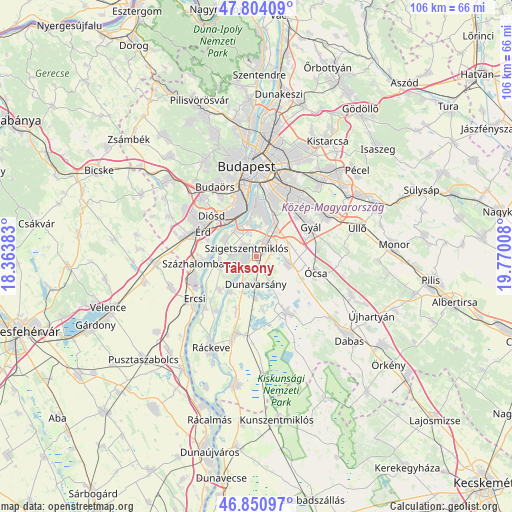
Taksony GPS coordinates[2]
47° 19' 46.848" North, 19° 4' 1.02" East
| Map corner | latitude | longitude |
|---|---|---|
| Upper-left | 47.80409°, | 18.36383° |
| Center: | 47.32968°, | 19.06695° |
| Lower-right: | 46.85097°, | 19.77008° |
| Map W x H: | 106×106 km | = 65.9×65.9mi |
| max Lat: | 48.46667° ⇑54.9% North |
| Taksony: | 47.32968° |
| min Lat: | ⇓45.1% South 45.79108° |
| min Long | Taksony | max Long |
| 16.27358° | 19.06695° | 22.68096° |
| W 38.8%⇐ | ⇒61.2% E |
Elevation
Elevation of Taksony is 105 m = 344 ft, and this is 24.7 m = 81 ft below average elevation for this country.
| Max E: |
444 m = 1457 ft | 66.2% |
| Avg. | 129.7 m = 426 ft | |
| Taksony | 105 m = 344 ft | |
Min E: |
71 m = 233 ft | 33.8% |
See also: Hungary elevation on elevation.city.
Geographical zone
Taksony is located in North temperate zone (between Tropic of Cancer and the Arctic Circle). Distance of this North polar circle is 2138.6 km =1328.9 mi to North.| Distance of | km | miles | from Taksony |
|---|---|---|---|
| North Pole | 4744.5 | 2948.1 | to North |
| Arctic Circle | 2138.6 | 1328.9 | to North |
| Tropic Cancer | 2656.6 | 1650.7 | to South |
| Equator | 5262.6 | 3270 | to South |


Nearby cities:
15 places around Taksony: (largest is in red/bold)
• Alsónémedi
7.1 km =4.4 mi,  103°
103°
• Budapest XX. kerület
12.2 km =7.6 mi,  12°
12°
• Budapest XXI. kerület
11.2 km =7 mi,  1°
1°
• Budapest XXII. kerület
11 km =6.8 mi,  349°
349°
• Budapest XXIII. kerület
8.4 km =5.2 mi,  25°
25°
• Diósd
12.6 km =7.8 mi,  314°
314°
• Dunaharaszti
3.6 km =2.2 mi,  40°
40°
• Dunavarsány
5.7 km =3.5 mi,  180°
180°
• Délegyháza
10 km =6.2 mi,  169°
169°
• Halásztelek
7.4 km =4.6 mi,  298°
298°
• Szigetcsép
10.2 km =6.3 mi,  225°
225°
• Szigethalom
4.9 km =3 mi,  260°
260°
• Szigetszentmiklós
2.4 km =1.5 mi, 311°
• Százhalombatta
9.7 km =6 mi,  269°
269°
• Tököl
7.9 km =4.9 mi, 263°
Sources, notices
• [Note1] Compared only with cities in Hungary existing in our database
• [Src1] Map data: © OpenStreetMap contributors (CC-BY-SA)
• [Src2] Other city data from geonames.org with taken over terms of usage.
• [Src3] Geographical zone / Annual Mean Temperature by Robert A. Rohde @ Wikipedia
