Szigetcsép geodata
Szigetcsép (Pest) is a populated place; located in Hungary in Europe/Budapest (GMT+2) time zone. With population of 2,455 people, there are 630 cities with bigger population in this country. Compared to other cities in Hungary, 58.5% of cities are located further ↑North; 65.3% of cities are located further →East and 72.5% of cities have higher elevation than Szigetcsép. Note1


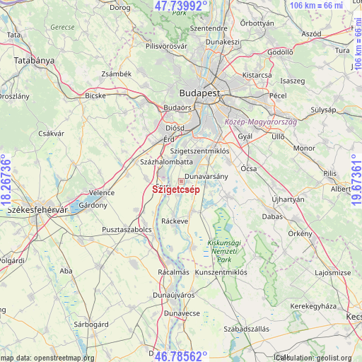
Szigetcsép GPS coordinates[2]
47° 15' 53.712" North, 18° 58' 13.728" East
| Map corner | latitude | longitude |
|---|---|---|
| Upper-left | 47.73992°, | 18.26736° |
| Center: | 47.26492°, | 18.97048° |
| Lower-right: | 46.78562°, | 19.67361° |
| Map W x H: | 106.1×106.1 km | = 65.9×65.9mi |
| max Lat: | 48.46667° ⇑58.5% North |
| Szigetcsép: | 47.26492° |
| min Lat: | ⇓41.5% South 45.79108° |
| min Long | Szigetcsép | max Long |
| 16.27358° | 18.97048° | 22.68096° |
| W 34.7%⇐ | ⇒65.3% E |
Elevation
Elevation of Szigetcsép is 100 m = 328 ft, and this is 29.7 m = 97 ft below average elevation for this country.
| Max E: |
444 m = 1457 ft | 72.5% |
| Avg. | 129.7 m = 426 ft | |
| Szigetcsép | 100 m = 328 ft | |
Min E: |
71 m = 233 ft | 27.5% |
See also: Hungary elevation on elevation.city.
Geographical zone
Szigetcsép is located in North temperate zone (between Tropic of Cancer and the Arctic Circle). Distance of this North polar circle is 2145.8 km =1333.3 mi to North.| Distance of | km | miles | from Szigetcsép |
|---|---|---|---|
| North Pole | 4751.7 | 2952.6 | to North |
| Arctic Circle | 2145.8 | 1333.3 | to North |
| Tropic Cancer | 2649.4 | 1646.3 | to South |
| Equator | 5255.4 | 3265.6 | to South |


Nearby cities:
15 places around Szigetcsép: (largest is in red/bold)
• Bugyi
13.9 km =8.6 mi,  107°
107°
• Dunaharaszti
13.9 km =8.6 mi,  44°
44°
• Dunavarsány
7.4 km =4.6 mi,  78°
78°
• Délegyháza
9.4 km =5.8 mi, 106°
• Ercsi
5.8 km =3.6 mi,  255°
255°
• Halásztelek
10.8 km =6.7 mi,  4°
4°
• Kiskunlacháza
9 km =5.6 mi,  160°
160°
• Ráckeresztúr
10.4 km =6.5 mi,  275°
275°
• Ráckeve
11.7 km =7.3 mi,  189°
189°
• Szigethalom
6.8 km =4.2 mi,  20°
20°
• Szigetszentmiklós
10.4 km =6.5 mi,  32°
32°
• Szigetújfalu
4.7 km =2.9 mi,  223°
223°
• Százhalombatta
7.6 km =4.7 mi,  341°
341°
• Taksony
10.2 km =6.3 mi,  45°
45°
• Tököl
6.4 km =4 mi,  354°
354°
Sources, notices
• [Note1] Compared only with cities in Hungary existing in our database
• [Src1] Map data: © OpenStreetMap contributors (CC-BY-SA)
• [Src2] Other city data from geonames.org with taken over terms of usage.
• [Src3] Geographical zone / Annual Mean Temperature by Robert A. Rohde @ Wikipedia
