Dunaharaszti geodata
Dunaharaszti (Pest) is a populated place; located in Hungary in Europe/Budapest (GMT+2) time zone. With population of 16,973 people, there are 103 cities with bigger population in this country. Compared to other cities in Hungary, 53.7% of cities are located further ↑North; 60% of cities are located further →East and 72.5% of cities have higher elevation than Dunaharaszti. Note1


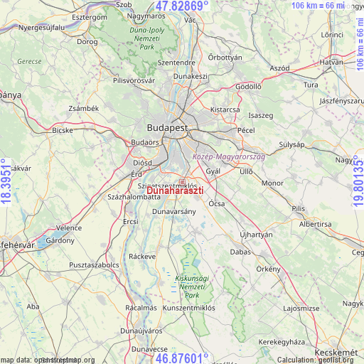
Dunaharaszti GPS coordinates[2]
47° 21' 16.2" North, 19° 5' 53.592" East
| Map corner | latitude | longitude |
|---|---|---|
| Upper-left | 47.82869°, | 18.3951° |
| Center: | 47.3545°, | 19.09822° |
| Lower-right: | 46.87601°, | 19.80135° |
| Map W x H: | 105.9×105.9 km | = 65.8×65.8mi |
| max Lat: | 48.46667° ⇑53.7% North |
| Dunaharaszti: | 47.3545° |
| min Lat: | ⇓46.3% South 45.79108° |
| min Long | Dunaharaszti | max Long |
| 16.27358° | 19.09822° | 22.68096° |
| W 40%⇐ | ⇒60% E |
Elevation
Elevation of Dunaharaszti is 100 m = 328 ft, and this is 29.7 m = 97 ft below average elevation for this country.
| Max E: |
444 m = 1457 ft | 72.5% |
| Avg. | 129.7 m = 426 ft | |
| Dunaharaszti | 100 m = 328 ft | |
Min E: |
71 m = 233 ft | 27.5% |
See also: Hungary elevation on elevation.city.
Geographical zone
Dunaharaszti is located in North temperate zone (between Tropic of Cancer and the Arctic Circle). Distance of this North polar circle is 2135.8 km =1327.1 mi to North.| Distance of | km | miles | from Dunaharaszti |
|---|---|---|---|
| North Pole | 4741.7 | 2946.4 | to North |
| Arctic Circle | 2135.8 | 1327.1 | to North |
| Tropic Cancer | 2659.4 | 1652.5 | to South |
| Equator | 5265.3 | 3271.7 | to South |


Nearby cities:
15 places around Dunaharaszti: (largest is in red/bold)
• Alsónémedi
6.3 km =3.9 mi,  133°
133°
• Budapest XIX. kerület
11.6 km =7.2 mi,  19°
19°
• Budapest XX. kerület
9.1 km =5.7 mi,  1°
1°
• Budapest XXI. kerület
8.7 km =5.4 mi,  346°
346°
• Budapest XXII. kerület
9.2 km =5.7 mi,  331°
331°
• Budapest XXIII. kerület
5 km =3.1 mi,  14°
14°
• Dunavarsány
8.8 km =5.5 mi,  195°
195°
• Felsőpakony
10.5 km =6.5 mi,  96°
96°
• Gyál
9.9 km =6.2 mi,  70°
70°
• Halásztelek
8.9 km =5.5 mi,  275°
275°
• Kispest
11.2 km =7 mi, 16°
• Szigethalom
8 km =5 mi,  243°
243°
• Szigetszentmiklós
4.3 km =2.7 mi,  253°
253°
• Taksony
3.6 km =2.2 mi,  220°
220°
• Tököl
10.9 km =6.8 mi, 250°
Sources, notices
• [Note1] Compared only with cities in Hungary existing in our database
• [Src1] Map data: © OpenStreetMap contributors (CC-BY-SA)
• [Src2] Other city data from geonames.org with taken over terms of usage.
• [Src3] Geographical zone / Annual Mean Temperature by Robert A. Rohde @ Wikipedia
