Dunavarsány geodata
Dunavarsány (Pest) is a populated place; located in Hungary in Europe/Budapest (GMT+2) time zone. With population of 6,016 people, there are 253 cities with bigger population in this country. Compared to other cities in Hungary, 57.9% of cities are located further ↑North; 61.3% of cities are located further →East and 77% of cities have higher elevation than Dunavarsány. Note1


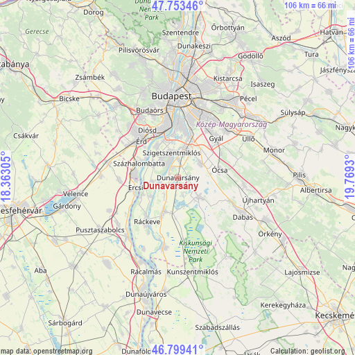
Dunavarsány GPS coordinates[2]
47° 16' 42.924" North, 19° 3' 58.212" East
| Map corner | latitude | longitude |
|---|---|---|
| Upper-left | 47.75346°, | 18.36305° |
| Center: | 47.27859°, | 19.06617° |
| Lower-right: | 46.79941°, | 19.7693° |
| Map W x H: | 106.1×106.1 km | = 65.9×65.9mi |
| max Lat: | 48.46667° ⇑57.9% North |
| Dunavarsány: | 47.27859° |
| min Lat: | ⇓42.1% South 45.79108° |
| min Long | Dunavarsány | max Long |
| 16.27358° | 19.06617° | 22.68096° |
| W 38.7%⇐ | ⇒61.3% E |
Elevation
Elevation of Dunavarsány is 97 m = 318 ft, and this is 32.7 m = 107 ft below average elevation for this country.
| Max E: |
444 m = 1457 ft | 77% |
| Avg. | 129.7 m = 426 ft | |
| Dunavarsány | 97 m = 318 ft | |
Min E: |
71 m = 233 ft | 23% |
See also: Hungary elevation on elevation.city.
Geographical zone
Dunavarsány is located in North temperate zone (between Tropic of Cancer and the Arctic Circle). Distance of this North polar circle is 2144.3 km =1332.4 mi to North.| Distance of | km | miles | from Dunavarsány |
|---|---|---|---|
| North Pole | 4750.2 | 2951.6 | to North |
| Arctic Circle | 2144.3 | 1332.4 | to North |
| Tropic Cancer | 2651 | 1647.3 | to South |
| Equator | 5256.9 | 3266.5 | to South |


Nearby cities:
15 places around Dunavarsány: (largest is in red/bold)
• Alsónémedi
8.1 km =5 mi,  59°
59°
• Bugyi
8.3 km =5.2 mi,  133°
133°
• Dunaharaszti
8.8 km =5.5 mi,  15°
15°
• Délegyháza
4.5 km =2.8 mi,  156°
156°
• Ercsi
13.2 km =8.2 mi,  256°
256°
• Halásztelek
11.2 km =7 mi,  325°
325°
• Kiskunlacháza
10.9 km =6.8 mi,  203°
203°
• Szigetcsép
7.4 km =4.6 mi, 258°
• Szigethalom
6.8 km =4.2 mi,  315°
315°
• Szigetszentmiklós
7.5 km =4.7 mi,  346°
346°
• Szigetújfalu
11.6 km =7.2 mi,  244°
244°
• Százhalombatta
11.1 km =6.9 mi,  300°
300°
• Taksony
5.7 km =3.5 mi,  0°
0°
• Tököl
9.2 km =5.7 mi, 301°
• Ócsa
12.6 km =7.8 mi,  79°
79°
Sources, notices
• [Note1] Compared only with cities in Hungary existing in our database
• [Src1] Map data: © OpenStreetMap contributors (CC-BY-SA)
• [Src2] Other city data from geonames.org with taken over terms of usage.
• [Src3] Geographical zone / Annual Mean Temperature by Robert A. Rohde @ Wikipedia
