Rajka geodata
Rajka (Győr-Moson-Sopron) is a populated place; located in Hungary in Europe/Budapest (GMT+2) time zone. With population of 2,601 people, there are 595 cities with bigger population in this country. Compared to other cities in Hungary, 87.1% of cities are located further ↓South; 95.2% of cities are located further →East and 62.1% of cities have lower elevation than Rajka. Note1


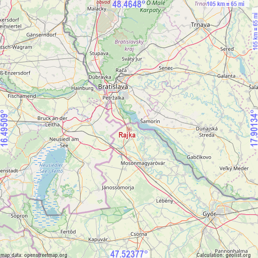
Rajka GPS coordinates[2]
47° 59' 47.148" North, 17° 11' 53.556" East
| Map corner | latitude | longitude |
|---|---|---|
| Upper-left | 48.4648°, | 16.49509° |
| Center: | 47.99643°, | 17.19821° |
| Lower-right: | 47.52377°, | 17.90134° |
| Map W x H: | 104.6×104.6 km | = 65×65mi |
| max Lat: | 48.46667° ⇑12.9% North |
| Rajka: | 47.99643° |
| min Lat: | ⇓87.1% South 45.79108° |
| min Long | Rajka | max Long |
| 16.27358° | 17.19821° | 22.68096° |
| W 4.8%⇐ | ⇒95.2% E |
Elevation
Elevation of Rajka is 128 m = 420 ft, and this is 1.7 m = 6 ft below average elevation for this country.
| Max E: |
444 m = 1457 ft | 37.9% |
| Avg. | 129.7 m = 426 ft | |
| Rajka | 128 m = 420 ft | |
Min E: |
71 m = 233 ft | 62.1% |
See also: Hungary elevation on elevation.city.
Geographical zone
Rajka is located in North temperate zone (between Tropic of Cancer and the Arctic Circle). Distance of this North polar circle is 2064.5 km =1282.8 mi to North.| Distance of | km | miles | from Rajka |
|---|---|---|---|
| North Pole | 4670.4 | 2902.1 | to North |
| Arctic Circle | 2064.5 | 1282.8 | to North |
| Tropic Cancer | 2730.8 | 1696.8 | to South |
| Equator | 5336.7 | 3316.1 | to South |


Nearby cities:
15 places around Rajka: (largest is in red/bold)
• Abda
42.4 km =26.3 mi,  142°
142°
• Bősárkány
34.5 km =21.4 mi,  173°
173°
• Csorna
43 km =26.7 mi, 174°
• Farád
43.4 km =27 mi,  179°
179°
• Halászi
15.3 km =9.5 mi, 141°
• Jánossomorja
23.8 km =14.8 mi,  191°
191°
• Kapuvár
46.7 km =29 mi,  195°
195°
• Kimle
23.5 km =14.6 mi,  147°
147°
• Kóny
42.4 km =26.3 mi,  163°
163°
• Lébény
32.3 km =20.1 mi, 153°
• Mosonmagyaróvár
15.3 km =9.5 mi, 159°
• Mosonszentmiklós
34.4 km =21.4 mi, 150°
• Rábapatona
45.6 km =28.3 mi, 152°
• Ásványráró
29 km =18 mi,  130°
130°
• Öttevény
37.5 km =23.3 mi, 145°
Sources, notices
• [Note1] Compared only with cities in Hungary existing in our database
• [Src1] Map data: © OpenStreetMap contributors (CC-BY-SA)
• [Src2] Other city data from geonames.org with taken over terms of usage.
• [Src3] Geographical zone / Annual Mean Temperature by Robert A. Rohde @ Wikipedia
