Mosonmagyaróvár geodata
Mosonmagyaróvár (Győr-Moson-Sopron) is a seat of a second-order administrative division; located in Hungary in Europe/Budapest (GMT+2) time zone. With population of 30,359 people, there are 59 cities with bigger population in this country. Compared to other cities in Hungary, 81.3% of cities are located further ↓South; 94.5% of cities are located further →East and 53.5% of cities have lower elevation than Mosonmagyaróvár. Note1


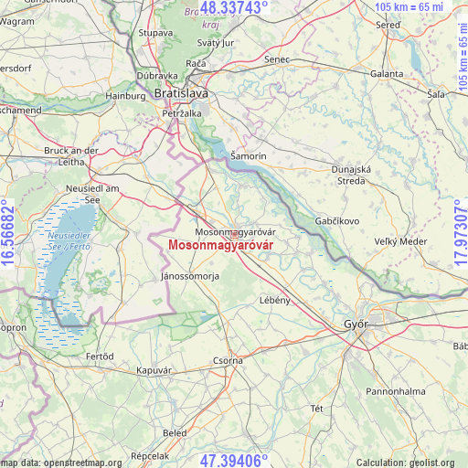
Mosonmagyaróvár GPS coordinates[2]
47° 52' 4.404" North, 17° 16' 11.784" East
| Map corner | latitude | longitude |
|---|---|---|
| Upper-left | 48.33743°, | 16.56682° |
| Center: | 47.86789°, | 17.26994° |
| Lower-right: | 47.39406°, | 17.97307° |
| Map W x H: | 104.9×104.9 km | = 65.2×65.2mi |
| max Lat: | 48.46667° ⇑18.7% North |
| Mosonmagyaróvár: | 47.86789° |
| min Lat: | ⇓81.3% South 45.79108° |
| min Long | Mosonmagyaróv� | max Long |
| 16.27358° | 17.26994° | 22.68096° |
| W 5.5%⇐ | ⇒94.5% E |
Elevation
Elevation of Mosonmagyaróvár is 119 m = 390 ft, and this is 10.7 m = 35 ft below average elevation for this country.
| Max E: |
444 m = 1457 ft | 46.5% |
| Avg. | 129.7 m = 426 ft | |
| Mosonmagyaróvár | 119 m = 390 ft | |
Min E: |
71 m = 233 ft | 53.5% |
See also: Hungary elevation on elevation.city.
Geographical zone
Mosonmagyaróvár is located in North temperate zone (between Tropic of Cancer and the Arctic Circle). Distance of this North polar circle is 2078.8 km =1291.7 mi to North.| Distance of | km | miles | from Mosonmagyaróvár |
|---|---|---|---|
| North Pole | 4684.7 | 2910.9 | to North |
| Arctic Circle | 2078.8 | 1291.7 | to North |
| Tropic Cancer | 2716.5 | 1688 | to South |
| Equator | 5322.4 | 3307.2 | to South |


Nearby cities:
15 places around Mosonmagyaróvár: (largest is in red/bold)
• Abda
28.2 km =17.5 mi,  133°
133°
• Bősárkány
20 km =12.4 mi,  184°
184°
• Csorna
28.5 km =17.7 mi, 182°
• Farád
29.5 km =18.3 mi,  190°
190°
• Halászi
4.8 km =3 mi,  60°
60°
• Jánossomorja
13.5 km =8.4 mi,  227°
227°
• Kimle
9.1 km =5.7 mi, 128°
• Kóny
27.2 km =16.9 mi,  166°
166°
• Lébény
17.2 km =10.7 mi,  148°
148°
• Mosonszentmiklós
19.5 km =12.1 mi,  142°
142°
• Rajka
15.3 km =9.5 mi,  339°
339°
• Rábacsécsény
33.4 km =20.8 mi,  159°
159°
• Rábapatona
30.5 km =19 mi, 149°
• Ásványráró
17.3 km =10.7 mi,  105°
105°
• Öttevény
23 km =14.3 mi, 135°
Sources, notices
• [Note1] Compared only with cities in Hungary existing in our database
• [Src1] Map data: © OpenStreetMap contributors (CC-BY-SA)
• [Src2] Other city data from geonames.org with taken over terms of usage.
• [Src3] Geographical zone / Annual Mean Temperature by Robert A. Rohde @ Wikipedia
