Hidas geodata
Hidas (Baranya) is a populated place; located in Hungary in Europe/Budapest (GMT+2) time zone. With population of 2,274 people, there are 683 cities with bigger population in this country. Compared to other cities in Hungary, 93.5% of cities are located further ↑North; 76.8% of cities are located further →East and 71% of cities have lower elevation than Hidas. Note1


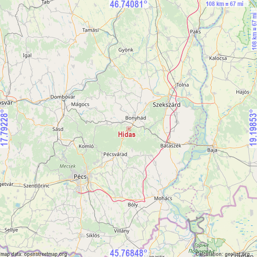
Hidas GPS coordinates[2]
46° 15' 24.48" North, 18° 29' 43.44" East
| Map corner | latitude | longitude |
|---|---|---|
| Upper-left | 46.74081°, | 17.79228° |
| Center: | 46.2568°, | 18.4954° |
| Lower-right: | 45.76848°, | 19.19853° |
| Map W x H: | 108.1×108.1 km | = 67.2×67.2mi |
| max Lat: | 48.46667° ⇑93.5% North |
| Hidas: | 46.2568° |
| min Lat: | ⇓6.5% South 45.79108° |
| min Long | Hidas | max Long |
| 16.27358° | 18.4954° | 22.68096° |
| W 23.2%⇐ | ⇒76.8% E |
Elevation
Elevation of Hidas is 139 m = 456 ft, and this is 9.3 m = 31 ft above average elevation for this country.
| Max E: |
444 m = 1457 ft | 29% |
| Hidas | 139 m 456 ft | |
| Avg. | 129.7 m = 426 ft | |
Min E: |
71 m = 233 ft | 71% |
See also: Hungary elevation on elevation.city.
Geographical zone
Hidas is located in North temperate zone (between Tropic of Cancer and the Arctic Circle). Distance of this North polar circle is 2257.9 km =1403 mi to North.| Distance of | km | miles | from Hidas |
|---|---|---|---|
| North Pole | 4863.8 | 3022.2 | to North |
| Arctic Circle | 2257.9 | 1403 | to North |
| Tropic Cancer | 2537.4 | 1576.7 | to South |
| Equator | 5143.3 | 3195.9 | to South |


Nearby cities:
15 places around Hidas: (largest is in red/bold)
• Bonyhád
5.4 km =3.4 mi,  29°
29°
• Báta
25.5 km =15.8 mi,  123°
123°
• Bátaszék
18.9 km =11.7 mi,  111°
111°
• Decs
20.6 km =12.8 mi,  81°
81°
• Hosszúhetény
15.2 km =9.4 mi,  227°
227°
• Komló
19.1 km =11.9 mi,  248°
248°
• Mecseknádasd
4 km =2.5 mi,  207°
207°
• Mágocs
22.7 km =14.1 mi,  297°
297°
• Nagymányok
4 km =2.5 mi,  308°
308°
• Pécsvárad
12.1 km =7.5 mi, 207°
• Szekszárd
19.4 km =12.1 mi,  57°
57°
• Szentgálpuszta
16.5 km =10.3 mi,  37°
37°
• Szászvár
9.5 km =5.9 mi,  283°
283°
• Zomba
18 km =11.2 mi,  17°
17°
• Őcsény
21.1 km =13.1 mi,  72°
72°
Sources, notices
• [Note1] Compared only with cities in Hungary existing in our database
• [Src1] Map data: © OpenStreetMap contributors (CC-BY-SA)
• [Src2] Other city data from geonames.org with taken over terms of usage.
• [Src3] Geographical zone / Annual Mean Temperature by Robert A. Rohde @ Wikipedia
